Four at High Noon: Duel in the
Desert
A Head to Head comparison of Hand Held GPS Units
 With handheld Global Positioning Systems (GPS) becoming increasingly popular with hikers, backpackers, mountain bikers, etc, I guess it was inevitable that four of us would show up in Albuquerque for a 9 day backpack in Utah's Dark Canyon Wilderness armed with hand held GPS units. The mix of operators seemed more diverse than the GPS units themselves: the operators ranged from a true newbie to highly experienced, while the units themselves were all Garmin (albeit each a different model). That they were all the same brand probably says more about market share and advertizing and quality of the support web site, rather than technological superiority. The operators put the GPS units through their paces in some potentially difficult terrain - for GPS's - high canyon walls that black out large portions of the sky. Here is a brief comparison of unit performance during the trip, which may be useful for people considering a purchase. The results may surprise you. But first, a bit of background.
For those of you living under a technological rock, GPS units act as satellite signal receivers, and use the information they receive to calculate the unit's position on the planet. As the cost of the units have plummeted and their capabilities increased, they have become immensely popular - both with folks who use the outdoors for recreation, as well as those who use them to navigate the wild concrete canyons of New York or San Francisco. Until very recently, the military deliberately introduced errors into the civilian frequencies, so that accuracy was degraded to about ± 100 feet or more. However, as the military demonstrated it could turn on and off this deliberate error - at will - in a hostile situation or area, the Clinton Administration acted to make a greater level of accuracy available to the general public. The President issued an executive order, effective midnight, May 1st, 2000, which effectively removed the "Selective Availability" error from the civilian frequencies. Overnight, estimated errors decreased to typically less than ± 15 feet. In other words, the GPS can tell you on which side of the campfire you are sitting. Pretty amazing. If you want to learn a bit more about how GPS works and how you might use it, go to our GPS Tutorial.
For most self-propelled outdoor recreation, a hand-held GPS is useful for two things: a) Telling you where you are - exactly, and b) where, relative to your current position, is an important location (eg., camp, the next spring, a key trail junction). But GPS is not a complete solution for finding your way to that next point. Remember that, if you are stationary, the GPS will give you a bearing (eg. 75 degrees) and a distance. But without a compass to point the way on the ground, the GPS can not tell you which direction you should head until after you have started moving. Secondly, a GPS is useless without a good topographical map. Sure, the GPS will tell you what your latitude, longitude, and elevation is, but without a map to provide reference, well, it is about as functional as a fish out of water. However, with a functioning GPS, an appropriate map and compass, and an understanding of how to use them, you will never be lost in the outdoors. That in itself, is a pretty amazing statement.
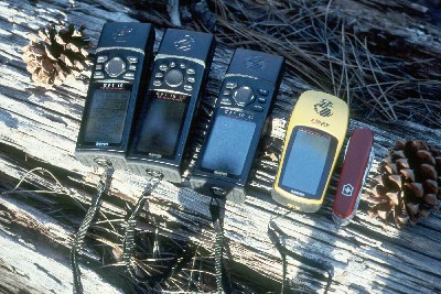
OK, back to Dark Canyon. So how did the units survive the field test? Amazingly well, is the short answer. The operators, relatively independently, had all purchased Garmin models: the new eTrex (~ $120), the Model 12 (~$150), the 12XL (~ $200), and the 12CX (~ $250). In terms of performance, they all did fine. That is, when compared head to head, they all provided a position which was within 15 feet or so of that reported by the others. We noted that the wonderfully light weight eTrex was a bit slower (maybe 15 - 20 seconds) at acquiring a position fix. Such may be due to a somewhat less sensitive built-in antenna or a less powerful receiver, but at nearly half the weight of the other units (about 5 oz vs. 9 oz), it is worth consideration. After working with these units for more than a week, some of the operators of the higher priced units thought that the eTrex interface was a bit cutesy for their taste, but in the end, it is probably worth buying a unit based on the features you feel like you need. All the units have 12 channel simultaneous reception, which is critical.
The eTrex is a lightweight, bare bones unit, but it is capable of downloads and uploads of waypoints using a computer and digital mapping software. ( A waypoint you establish either in advance of your trip or during the trip, to, for example, mark a spot which might be important to you later. For example, you set up camp in an unknown spot above timberline. You go off on a day hike, but the fog rolls in big time. Wouldn't it be nice to be able to get back to camp easily if the visibility has been reduced to 50 feet?) The eTrex has a slightly smaller display than the others, but it can store up to 500 waypoints. (Why would you want 500 waypoints? Read below.) The other units provide more information, and provide it more easily during readout. Probably the most useful information is a satellite constellation map. These units store the almanac of orbits of the 24+ GPS satellites. (Remember that the satellites are not geosychronous, so their position relative to yours changes by the minute.) A constellation map is useful to tell you why you are or are not getting a rapid position fix. Sometimes, there may be only two or three satellites above the 45 degree angle in the sky (you need four to get a reliable position fix with an elevation and reflected signal error correction) and the others may be obscured by mountain peaks or canyon walls. The 12XL adds an external antenna connection, a database of hundreds of cities around the world, and an audible alarm as you approach pre-determined waypoints. The 12 CX has a color screen, which may be easier to read for some folks, and can store up to 1000 waypoints. I personally own the 12XL, and am quite pleased with it. All the units are waterproof, but I would not throw mine in the creek just to test such. Clearly, occasional raindrops should not be a problem.
A couple of final comments. There are a huge number of additional features and capabilities in each of these units, most of which you probably will not use. (However, for most technology, we only use a small fraction of its capability. Think what portion of your word processor's power you use.) For example, a few weeks ago, sitting in a window seat on the plane, I was able to determine with my GPS held against the window, that we were traveling at a ground speed of 608 miles per hour, and 483 miles away from the center of Atlanta. And if you mate these units with street mapping software in a notebook computer, you can use them to navigate roads with amazing accuracy. One of the surprisingly useful capabilities is the storage of a large number of waypoints. Ever been hiking on a trail, and it did not seem as though the route on the map was congruent with your "ground truth"? It probably was because the trail was mapped incorrectly. However, with these units, there are no more excuses for inaccurate trail mapping. Just turn them on, and have them store waypoints periodically, like every minute. When you get back, just download the stored waypoints onto a digital map, and bang, the trail is mapped. One of the things I really love is that the GPS settles all arguments as to where we are, or how far we got or how far it is to a certain location. Sure, there is still room for opinion: about 15 feet.
© Roger A. Jenkins, 2000, 2002