Pasayten 2000
Upper Cathedral Lake to Remmel Lake
Thursday, September 7
 We awoke to high thin clouds, but I could see some low clouds filling the valleys to the northwest. It would be interesting to see what Mother Nature would throw at us today. The breeze had picked up in the middle of the nite, and while I figured that boded no good for the long haul, the temperature had never dropped to freezing and as a result, out tents were nice and dry. Distance-wise, we would have it pretty easy: a short three miles or so over to Remmel Lake. The point was to stay in the high country as long as possible. Since the day was short, no one seemed to be in much of a hurry. We spent a lot of time watching curious deer while we ate breakfast. A doe and her 5-month old seemed especially interested in us.
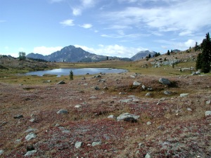
We pulled out of Cathedral Lake Camp at about 9:30, and headed across this huge rock field. To make the Boundary Trail at this point, the builders had blasted out this corridor, so the route - undoubtedly to benefit the four-legged canvas-lugging beasts that the trail seemed to have been made for - was more like a highway. The trail then goes around the west end of Peak 8252, and climbs to a small saddle in the sub-alpine zone. This is what I had been waiting to see: I have been looking at a photo in 101 Hikes in the North Cascades for over 20 years, and telling myself I had to see the place, and now I was here: a small tarn in the foreground, the meadows turning red and gold in early autumn, and Remmel Mountain in the distance. And still a bit of blue sky up above, although it was clear it would not be for long. We got to the spot where a trail leaves the Boundary Trail, and takes a more direct route to Remmel Lake. Or so we thought.
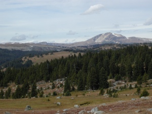 We came upon Andy sitting on top of a rock, by himself. We asked where everyone else was, and he indicated, with more than a hint of sarcasm in his voice, that he was not sure. It seems that Tim and Diane, who, unbelievably, were out here without maps, had taken off in one direction, and Sue and Ray, had sorta gone in the direction of a trail heading southwest, with Sue carrying the community topo maps with her. It turns out that the trail junction, which the topo map shows as being at 704044 East, 5427760 Northing, really doesn't look that way. The junction, if you can call it that, is unmarked, and the trail going off to the southeast, the one you want to take the most direct route to Remmel Lake, was faint to the point of being indistinguishable. However, if you get maybe 50 or 100 feet beyond the "junction," you can see the trail going in the direction you want. Before long, Sue and Ray showed up, retracing their steps. We decided that eventually Tim and Diane would realize they had made a mistake, and would either take the long way to Remmel Lake, or retrace their steps. So we took off, but of course, were left in Ray, Andy, and Sue's figurative dust. Susie and I began the long gradual climb to another saddle, stopping frequently to drink in the views. To the west, perhaps 50 miles away, it was possible to see the Picket Range, in North Cascades National Park. High, thin clouds were also moving in.
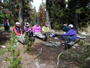
We heard someone call to us from the rear. It was Tim, perhaps now a quarter mile back, yelling, "Which way are you going?" I yelled back, "The RIGHT way!!" So they took off after us, and without the responsibilty of having to capture nearly every possible view with film and electrons, quickly caught up and passed us. We got to the spot where the trail was supposed to split again (UTM Coords 705030 Easting, 5426537 North), with the right fork leading down to Remmel Lake. Another good reason why it never hurts to pull out the map and the GPS, and try to reconcile the topo map with ground truth. We never did find a trail fork, but the trail leads through some horse-impacted muddy spots and eventually comes out on the north side of Remmel Lake. Truth be told, I was holding my breath a bit: the hiking guides refer to this as one of the single best spots to collect horse apples anywhere in the Wilderness. However, after a bit of searching, and a willingness to minimize our impact (that's the excuse we used) by spreading out over 10 acres or so, we situated ourselves, and had a relaxed lunch.
 Always the one to do everything I can to insure a maximum amount of protein flows into my system, I encouraged Tim to wet his line, while Susie and I decided to explore the outlet of the lake. As we were leaving camp, Susie had the idea of taking our bath stuff with us (we had carried small day packs with us for our layover day, so carrying extra stuff was no big deal). Recognizing the potential to get cleaned up even earlier in the day, I heartily concurred. We did not quite make it around to the outlet before we came to a sheltered spot, which even had a bit of sun on it. At least it was semi-sheltered. Occasionally, the breeze would shift, and goose bumps would abound. We followed the outlet down an interesting draw, and saw Tim fishing in a pond. He later announced that he had in fact, actually caught a fish, but 5 inches or so seemed barely worth any more effort than a simple catch and release. After poking around a bit, Susie and I completed our "circumnavigation" of the Lake, while Andy and Sue reported back that they had day hiked down to the cabin a couple of miles west of the lake.
Dinner was tuna/cheese and rice, underneath the tarp we had erected, to ward off the rain gods. The tarp did a pretty good job, and although the clouds showed us their dark underbellies, the sprinkles only lasted a moment or two. We built a fire, which added to the ambiance a lot, and told stories of hikes past and future. Who knows what tomorrow would bring?
© Roger A. Jenkins, 2000