Royal Basin/Constance Pass - 1990
Solo Adventure in the Olympics
Disappointment Col
Wednesday, September 5
 As I look back on this trip, it is hard for me to recall a time when I have been so utterly disgusted with my poor wilderness performance as this morning. TSFB was working overtime. I was underway by 8:12 am, and unquestioningly heeded the advice of the day hikers from yesterday: take the more easterly approach. It's easier. So, without looking at my compass, or doing any reconnoitering, I headed SSE out of camp, cross coutry toward the saddle that would supposedly lead me to Deception Basin. The climbing was not too bad, but there was some steep, loose scree in places. Apparently, I was not paying attention to the fact that I was curling more and more to the east. At 9:18 am, I reached the crest, and boy did I feel really stupid. I was looking down into the upper reaches of Milk Creek, far away from where I wanted to be. I just sttod there in shock for a moment, incredulous at my own incompetence. Sure, the left route might have been easier. Only one problem: it did not go to the place I wanted to be. Recalling the exchange with the hikers from yesterday, I realized that I had never asked them about what they had seen from each crest.
I had little choice if I was to get to Deception Basin and go up the Mystery Glacier. Since there were intervening cliffs between my current position and the saddle immediately to the east of Mt. Deception , where I was supposed to be, I would have to descend the 1000 feet I had just gained, and climb back up to the aforementioned saddle. I started to drop back down, hoping for a higher elevation traverse, but no such luck: I had to come within a couple of hundred meters of camp before I could resume climbing. I was down by 10:28, and immediately took off for what I would call Deception Col. Whew, it was rougher. Much steeper, and the scree was very loose. It seemed I would slide back a step for every two I would take.
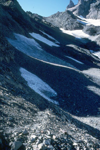
 I reached the Col (Zone 10, 483,356 East, 5, 295265 North) at 11:55 am, and was immediately confronted with two bits of disappointing information. First, it was clear, looking across the valley at Mystery Glacier, there was no way I could climb up the face of the glacier. Way too heavily crevassed. What's more, the hogback route to the left of the glacier would not go either: to get to the pass at the head of the glacier requires crossing what at this time of year was a huge bergschrund (the big crack between the rock at the head of the glacier and the start of the actual ice.) There was obviously no way I could do that part of the route safely. More immediately, however, was the question of exactly how I would get off the col in the direction of Deception Basin. The Climber's Guide refers to "descend open slopes....." Sure, they are open, alright. Just like a big steep cliff. A steep cliff; devilishly steep. I decided to take off my pack, munch on some jerky and cheese for lunch and contemplate my choices, the number of which seemed pretty limited. I could either turn around, and hang out for a few days in some other backcountry spot, or I could find a way down. After some walking around, it seemed that about 30 meters to the west of where I had come into the Col, there was sort of a path down really hard packed dirt and scree. The first 300 feet seemed horribly steep, and the first 50 feet of that seemed nearly suicidal. But I kept staring at the words in the Climber's Guide, and thought: "Look, other folks must do this all the time.
 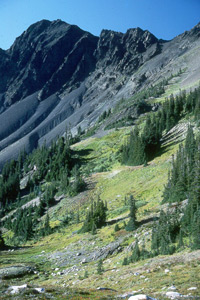 Maybe it won't be so bad once I get started."
Right. After having a bit more jerky and a granola bar (which seems pretty low brow for a last meal?), I hoisted my pack, having strapped on my camera tripod, got my ice axe out, and headed over to the gully that seemed the easiest was down. I started down face into the gully, needing both hands to hold on, and letting my ice axe dangle from my wrist. It was really hairy. Probably the hairiest thing I had done up to that point (nothing during the five days I was on and summited Ranier came even close to this level of intensity). Shortly after I turned sideways and started to sidestep down the slope, my right boot hit some stones, I fell into the slope on my left side and started to slide. I can recall thinking: Boy, it is going to take a long time for the resulting scar tissue to heal on my left arm. (As I look at it today, nearly10 years later, it is still visible.) Having my ice axe at the ready really helped, and I probably arrested after sliding only 30 or 40 feet. I was shaken up, and a really filthy mess, covered with dirt and little tiny stones which seemed to have found new homes in my skin, and there seemed to be more blood than I had expected coming from my left arm, and leg, and a couple of knuckles, but otherwise, I was OK. With excruciating care, I got back up on my feet, and resumed my descent. After a few hundred feet, the slope eased up a bit, and I finally felt I could walk with my feet to the front of me.
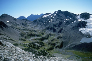
I made it to the floor of Deception Basin at 1:40 pm, and came to grips with the fact that I was through with hiking for the day. I needed time to clean myself up, dress my wounds, come up with a plan as to how to exit this lovely basin, and enjoy the afternoon sunshine. I decided on a spot to pitch my tent, and took off, looking for another potential route around Mt. Mystery. Gunsight Pass is the other recommended route, but as I explored to the point where Deception creek begins its precipitous plunge toward the Dosewallips River, it was clear that to get to the approach to Gunsight Pass without losing lots of elevation would require a huge amount of cross-country work thru very heavy vegetation. 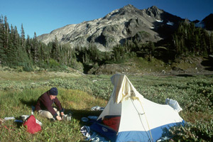 It was becoming increasingly clear that the only way out of here was down Deception Creek. Given that the creek loses more than 2600 feet in little more than 2 miles, and that it was clear that to do the descent, one would have to start by hopping bowling ball-sized talus, and then get into the really fun stuff along the vegetation-choked creek, I could see that tomorrow could be just about as much fun as I could tolerate. Given the bleak outlook, I decided to relax and enjoy the rest of the afternoon. After all, Deception Basin is a gorgeous spot, and it is visited only rarely. A sort-of ShangriLa of the Olympics. I would imagine that there must be dozens of spots like this all through these mountains, just waiting to be visited by someone willing to endure the effort and pain to get there.