Weminuche Wilderness 1999
Along the divide
 We were greeted by a lovely blue sky, with just a few puffy clouds around. So we tried to be optimistic. We had
done a pretty good job of situating the tent so it could catch some rays first, thing, but we still did not have full
sunlight until 7:45 or so. Being able to dry out the tent meant I could actually benefit from having eaten the nice
heavy dinner the night before. We pulled out of camp about 9 am. The other folks seemed to have just started
stirring. The first thing we noted was that the trail is not as advertized. Instead of crossing the stream at the lower
end of the meadow and heading north to the edge of the woods, it skirts the meadow on the right back in the
woods. (Can you spell mud hole? Lordy, it took us a long time to get through that mess.) The trail crosses the
creek, and heads northeast, but it becomes very faint for maybe 50 meters. Susie suffered the same fate as the
hunter, and missed the trail junction at first. I thought I could see it going off to the NE, so I asked Susie to scout
it, while I compared my position with pre-programmed GPS coordinates. I confirmed that I was practically
standing on the junction, and about this time Susie came back to report that indeed, the trail, once in the woods,
went exactly like it was supposed to. So we spent a bit of time marking the junction and trail start with some
cairns, and took off. As expected, once the trail entered the woods, it was a mess. Very tough to go more that 50
meters without encountering major damage. The trail had a couple more switchbacks than shown on the topo map,
but was no problem to follow. After a rest break we started contouring around a knoll (12,153 feet). Again, the
trail is not as advertised, but goes much further to the north, before it switchbacks into a saddle north of the knoll.
We stopped to catch our breaths, enjoying the view over to the east. Finally, we were getting some views. I felt
like I had been hiking in the woods forever. A very steep climb (requiring some pressure breathing by yours truly)
took us to the junction with the divide.
We were greeted by a lovely blue sky, with just a few puffy clouds around. So we tried to be optimistic. We had
done a pretty good job of situating the tent so it could catch some rays first, thing, but we still did not have full
sunlight until 7:45 or so. Being able to dry out the tent meant I could actually benefit from having eaten the nice
heavy dinner the night before. We pulled out of camp about 9 am. The other folks seemed to have just started
stirring. The first thing we noted was that the trail is not as advertized. Instead of crossing the stream at the lower
end of the meadow and heading north to the edge of the woods, it skirts the meadow on the right back in the
woods. (Can you spell mud hole? Lordy, it took us a long time to get through that mess.) The trail crosses the
creek, and heads northeast, but it becomes very faint for maybe 50 meters. Susie suffered the same fate as the
hunter, and missed the trail junction at first. I thought I could see it going off to the NE, so I asked Susie to scout
it, while I compared my position with pre-programmed GPS coordinates. I confirmed that I was practically
standing on the junction, and about this time Susie came back to report that indeed, the trail, once in the woods,
went exactly like it was supposed to. So we spent a bit of time marking the junction and trail start with some
cairns, and took off. As expected, once the trail entered the woods, it was a mess. Very tough to go more that 50
meters without encountering major damage. The trail had a couple more switchbacks than shown on the topo map,
but was no problem to follow. After a rest break we started contouring around a knoll (12,153 feet). Again, the
trail is not as advertised, but goes much further to the north, before it switchbacks into a saddle north of the knoll.
We stopped to catch our breaths, enjoying the view over to the east. Finally, we were getting some views. I felt
like I had been hiking in the woods forever. A very steep climb (requiring some pressure breathing by yours truly)
took us to the junction with the divide.
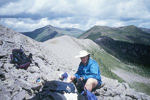
 What a spot. No question you are on the divide. You can look to the north and see the Rio Grande River valley,
and to the south is Williams Creek, which flows into the Piedra River, which flows into the San Juan just west of
Pagosa Springs, which flows into the Colorado. We stood on a relatively narrow spine of rock and rubble,
photographing the Continental Divide trail sign. I decided that it was a bit too breezy for my tastes if we were to
stop in an unsheltered spot, so we hiked a hundred meters or so and dropped off into a depression in the rocks to
get out of the wind. It was sunny but cool. But it was good to sit down and relax. At least for a bit. We were just
finishing up, and there was crack of thunder. We looked up, over to the west of us, and could see a big storm
brewing, and it seemed like it was moving toward us. Susie felt like we had to get moving because of our exposed
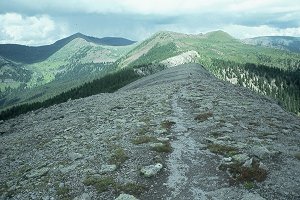
nature. She was correct in that, for at least 800 meters or so, the trail was on a totally exposed spine of rock. We
would be the highest objects for a half a mile.
Not a comfortable place to be with the storm moving in. I was not
ready to move, and nearly barfed lunch twice as I tried to keep up with Susie, but she was driven by adrenaline, not
muscles at this point, so I just did the best I could. We knew where Tim, Diane, Andy and Sue should be at this
point (nearing Squaw Pass), and suspected they were getting clobbered. The more I hiked (sorta like tying to jog
with a backpack on: no wonder I was belching lunch), the more comfortable I became with our situation. The
storm seemed to be tracking almost due north, which would keep it west of us. Secondly, the closest blast of
lightening was about a mile away, which, while close, is not close enough to scare me. Finally, our pace was
What a spot. No question you are on the divide. You can look to the north and see the Rio Grande River valley,
and to the south is Williams Creek, which flows into the Piedra River, which flows into the San Juan just west of
Pagosa Springs, which flows into the Colorado. We stood on a relatively narrow spine of rock and rubble,
photographing the Continental Divide trail sign. I decided that it was a bit too breezy for my tastes if we were to
stop in an unsheltered spot, so we hiked a hundred meters or so and dropped off into a depression in the rocks to
get out of the wind. It was sunny but cool. But it was good to sit down and relax. At least for a bit. We were just
finishing up, and there was crack of thunder. We looked up, over to the west of us, and could see a big storm
brewing, and it seemed like it was moving toward us. Susie felt like we had to get moving because of our exposed
nature. She was correct in that, for at least 800 meters or so, the trail was on a totally exposed spine of rock. We
would be the highest objects for a half a mile.
Not a comfortable place to be with the storm moving in. I was not
ready to move, and nearly barfed lunch twice as I tried to keep up with Susie, but she was driven by adrenaline, not
muscles at this point, so I just did the best I could. We knew where Tim, Diane, Andy and Sue should be at this
point (nearing Squaw Pass), and suspected they were getting clobbered. The more I hiked (sorta like tying to jog
with a backpack on: no wonder I was belching lunch), the more comfortable I became with our situation. The
storm seemed to be tracking almost due north, which would keep it west of us. Secondly, the closest blast of
lightening was about a mile away, which, while close, is not close enough to scare me. Finally, our pace was
 getting us to a more protected area, the spot where the trail cuts east of the actual divide, and you are not longer on
a spine, but slabbing around with maybe 200 feet of mtn above you. Much more comfortable. We continued to
move quickly because we could not tell if we were going to get hit by the storm. As we contoured around, Susie
wanted to know where the lake (Cherokee Lake) was. I told her she could see it just around the corner. She
interpreted that to mean that the lake was just around the corner. She was disappointed when she turned the
corner: "Where the hell is the lake?" she said. I pointed it out as a green line in the distance as being Cherokee
Lake. We were at nearly the same elevation as the lake, so it was a bit tough to see. But it was still a third of a
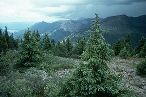
mile away. We continued to contour, getting to the lake at an amazing 1:35 pm. Cherokee Lake is really more of
a shallow pond, perched on a shelf a couple of hundred feet above a lovely meadow.
getting us to a more protected area, the spot where the trail cuts east of the actual divide, and you are not longer on
a spine, but slabbing around with maybe 200 feet of mtn above you. Much more comfortable. We continued to
move quickly because we could not tell if we were going to get hit by the storm. As we contoured around, Susie
wanted to know where the lake (Cherokee Lake) was. I told her she could see it just around the corner. She
interpreted that to mean that the lake was just around the corner. She was disappointed when she turned the
corner: "Where the hell is the lake?" she said. I pointed it out as a green line in the distance as being Cherokee
Lake. We were at nearly the same elevation as the lake, so it was a bit tough to see. But it was still a third of a
mile away. We continued to contour, getting to the lake at an amazing 1:35 pm. Cherokee Lake is really more of
a shallow pond, perched on a shelf a couple of hundred feet above a lovely meadow.
We were greeted by a bearded "Mike" when we arrived. Mike was a graduate of Columbine High School (made famous last spring with the mass shootings by a couple of crazy students) who had unemployed himself from the world of software development (he had worked for a company in Denver after graduating from college), and had left Denver on July 11, backpacking toward the Continental Divide Trail on the Colorado Trail. He said he was moving pretty good, but that the weather had been rough (only 3 days without rain since July 11!!!!), so he had stopped here to make it an easy day. Mike seemed to be starved for company, as I would be had I been solo hiking for more than 7 weeks. He suggested a better spot to put up our tent (we did not want to crowd him too much, and also wanted some space ourselves, but there were only a few spots to set up camp). He walked over to the site with us, and when it started showering, helped us get our tent up fast. He seemed like a nice guy, and had many tales of his travels. He was heading for Wolf Creek Pass to end his hike (he wanted to start looking for work in the Pagosa Springs area), but was thinking of going out to the Williams Creek trail head instead.
The shower was quite brief, and so we both cleaned up, and Susie said she was tired of pumping water, and remembered a spring crossing the trail just a bit back. (I remembered the spring, but it seemed to be a long way back on the trail, but if she wanted to haul the water, who was I to criticize?) The sun came out (on our camp, but black-undersided clouds prevented me from roaming) and the afternoon was warm. Susie had found some nice wildflowers near the water (including what we later learned was Western Fringed Gentian - our first time seeing that one) so I spent a bit of time photographing. The couple from Michigan finally showed up at the Lake, admitting that they had gotten a much later start than planned. They indicated that they found the rock cairns helpful, so I guess spending the time setting them up was worth it. The woman asked me if I minded if they stripped down and hopped in the lake, and I thought to myself, "Yeah, I really hate the sight of a naked woman cavorting in the water!" Instead, I just said, "Don't mind a bit, they call me the Big Dipper, because of my reputation for taking baths."
We were camped only about 35 feet from the edge of this precipice, falling away for about 200 feet. It gave me an uncomfortable feeling in my guts to stand very near the edge, but it afforded such great views, it was hard to resist. We kept looking for elk, but no luck. Eventually, we got around to cooking dinner near some logs under the trees. The latter would afford some protection when the showers came by, which they did with some regularity. Dinner was Cajun Rice and Beans with dried ham. Lots of it, and nice and spicy. About 8 pm, a big time shower hit, and we crawled in the tent, mostly for good. We got out after about 90 minutes when it stopped, to use the facilities, but during the night, it rained hard for 45 - 60 minutes. I was afraid this was signaling a change for the worse in the weather.
© Roger A. Jenkins, 1999