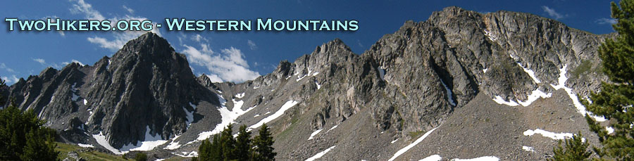
Who Needs Patagonia?
Wind Rivers: Big Sandy to East Fork Valley
Layover
Wednesday, September 12
 Another clear blue sky, cool (32
degrees) morning. We opted not to be in any kind of hurry, keeping
with the leisurely "theme" of the trip, and also, because it was cool.
We were fixing breakfast, when a couple of backpackers walked by our
camp, headed south. They were classical musicians from the
Philadelphia area, making their third backpacking trip to the Winds
THIS SEASON. I immediately felt guilty - we should have been going
here much more often, but alas, SW Montana has a lot of great
backpacking as well. We left camp at 9:39 am, headed for Pyramid Lake.
Hiking on trail, the route to Pyramid has a steep stretch once you
pass the NW end of Maes Lake, but from there, things are pretty
gentle.
Another clear blue sky, cool (32
degrees) morning. We opted not to be in any kind of hurry, keeping
with the leisurely "theme" of the trip, and also, because it was cool.
We were fixing breakfast, when a couple of backpackers walked by our
camp, headed south. They were classical musicians from the
Philadelphia area, making their third backpacking trip to the Winds
THIS SEASON. I immediately felt guilty - we should have been going
here much more often, but alas, SW Montana has a lot of great
backpacking as well. We left camp at 9:39 am, headed for Pyramid Lake.
Hiking on trail, the route to Pyramid has a steep stretch once you
pass the NW end of Maes Lake, but from there, things are pretty
gentle.
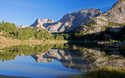
 As we got to the SE end of
Pyramid Lake, we looked around for some supposed campsites. There seem
to be some up on a small hill in some trees to the left but they
appeared to offer minimal shelter. But then, you don't come to Pyramid
looking for shelter. You come for the views. The Earthwalk Press map
shows, incorrectly, the XC (cross country) route heading up to the
west just past a couple of domes, slightly south of west of the Lake.
Well, I guess one could go that way, but we had to hike up nearly to
the NW end of the Lake before we picked up an obvious low-energy
route. (Why climb steeply when you can climb gently?) A path started
in the vicinity of a small pond, near 12T, 638141 E, 4744626 N. As we
climbed up past the first pond, we picked up an obvious path. Seemed
too strong for a critter path, but I am sure that larger critters use
it. Basically, we were heading for the saddle about a half mile west
of the Lake, and by the time we got near the saddle itself, the path
was approaching the strength of a trail.
As we got to the SE end of
Pyramid Lake, we looked around for some supposed campsites. There seem
to be some up on a small hill in some trees to the left but they
appeared to offer minimal shelter. But then, you don't come to Pyramid
looking for shelter. You come for the views. The Earthwalk Press map
shows, incorrectly, the XC (cross country) route heading up to the
west just past a couple of domes, slightly south of west of the Lake.
Well, I guess one could go that way, but we had to hike up nearly to
the NW end of the Lake before we picked up an obvious low-energy
route. (Why climb steeply when you can climb gently?) A path started
in the vicinity of a small pond, near 12T, 638141 E, 4744626 N. As we
climbed up past the first pond, we picked up an obvious path. Seemed
too strong for a critter path, but I am sure that larger critters use
it. Basically, we were heading for the saddle about a half mile west
of the Lake, and by the time we got near the saddle itself, the path
was approaching the strength of a trail.
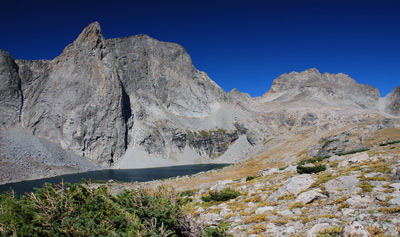
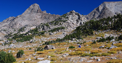
 As we pulled into the saddle, we
just had to stop in awe. Susie exclaimed: "Wow!! Who needs
Patagonia??" Indeed. The upper valley of the East Fork was simply
spectacular. No other way to put it. "Ambush Peak" I believe is the
name of the tooth-like granite spire that greets those arriving at the
saddle. The string of mountains on the same face as the tooth is
dramatic, which is a little like saying that the Tetons are nice
mountains. Way way understated. In a way, this was sort of a
homecoming for the two of us: Susie and I had been on the other side
of those mountains, camping in the shadow of Raid Peak and Mt
Bonneville, 25 years ago with our respective ex-spouses.
As we pulled into the saddle, we
just had to stop in awe. Susie exclaimed: "Wow!! Who needs
Patagonia??" Indeed. The upper valley of the East Fork was simply
spectacular. No other way to put it. "Ambush Peak" I believe is the
name of the tooth-like granite spire that greets those arriving at the
saddle. The string of mountains on the same face as the tooth is
dramatic, which is a little like saying that the Tetons are nice
mountains. Way way understated. In a way, this was sort of a
homecoming for the two of us: Susie and I had been on the other side
of those mountains, camping in the shadow of Raid Peak and Mt
Bonneville, 25 years ago with our respective ex-spouses.
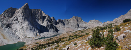
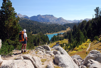
 OK, it was windy. We looked at
the terrain and opted for a modification of our original plans, which
had involved dropping down into the East Fork basin and getting up
close and personal with the string of lakes. We decided we could see a
lot more if we stayed high, and contoured at a constant elevation
about 10,700 feet up the valley. That was our excuse, anyway. We
slowly made our way on what amounts to a gently sloped shelf toward
the head of the valley, just drinking in the views. The wind was
pretty significant, and we got to a nice view of the head of the
valley, standing about 12T, 636659E, 4745541N, looking at another
tooth-like peak just south of Raid Peak. We decided to turn around and
look for a sheltered spot out of the wind. Thankfully, we found a
large boulder behind which we could hunker down and still get a great
view of the lakes and peaks. My sense is that camping along the
lakeshores would be pretty stark. Not much grass, just a lot of rocks.
Very pretty to look at, but not as much fun for camping, UNLESS you
like really dramatic views from your campsites. And most of us just
hate that kind of thing, right?
OK, it was windy. We looked at
the terrain and opted for a modification of our original plans, which
had involved dropping down into the East Fork basin and getting up
close and personal with the string of lakes. We decided we could see a
lot more if we stayed high, and contoured at a constant elevation
about 10,700 feet up the valley. That was our excuse, anyway. We
slowly made our way on what amounts to a gently sloped shelf toward
the head of the valley, just drinking in the views. The wind was
pretty significant, and we got to a nice view of the head of the
valley, standing about 12T, 636659E, 4745541N, looking at another
tooth-like peak just south of Raid Peak. We decided to turn around and
look for a sheltered spot out of the wind. Thankfully, we found a
large boulder behind which we could hunker down and still get a great
view of the lakes and peaks. My sense is that camping along the
lakeshores would be pretty stark. Not much grass, just a lot of rocks.
Very pretty to look at, but not as much fun for camping, UNLESS you
like really dramatic views from your campsites. And most of us just
hate that kind of thing, right?
 After lunch, we headed south
along the shelf, passing the low point in the saddle, to get a good
look downstream, and a wide angle view of the entire upper East Fork
valley. Well worth the effort, which frankly, was not that much. We
took a bunch of photos, trying to suck it all in and then headed back
for the saddle, and eventually camp. We tried a slightly different
route around the easternmost dome to the west of Pyramid Lake. It
ended up being steeper, and not as easy, but it was no problem.
Variety is the spice, and all that….
After lunch, we headed south
along the shelf, passing the low point in the saddle, to get a good
look downstream, and a wide angle view of the entire upper East Fork
valley. Well worth the effort, which frankly, was not that much. We
took a bunch of photos, trying to suck it all in and then headed back
for the saddle, and eventually camp. We tried a slightly different
route around the easternmost dome to the west of Pyramid Lake. It
ended up being steeper, and not as easy, but it was no problem.
Variety is the spice, and all that….
We were back in camp by 2:40 and decided we would hike off trail to a small lake SE of the south end of Maes Lake. We found a campsite and fire ring up in there, and I guess it would be a fine place to get away if the hordes were out at Maes Lake. But the views were nowhere near as good. Dinner was some Lipton veggie side dish with dried tuna in it. It was OK, but it is worthwhile to note that we did not take it on our next long backpack, the 2008 Canyon trip. We eventually threw in the towel, acknowledging that we were tired of the wind, and decided to go in tentia at 6:30 pm. The high temp for the day had been 52 degrees. Fine in the sun, with no wind, but cooling otherwise. Both of us had taken a book and while it was another evening of achingly blue skies, we had endured the wind long enough today. Certainly, it was a small price to pay for the scenery. Susie wanted to zip our sleeping bags together. Both of us had our feathered friends bags on this trip. However, her's is a barrel bag and mine is a mummy. It felt a little weird, but good to be close to each other.
To view supplemental photos of this trip, go to our TwoHikers SmugMug gallery.
© Roger A. Jenkins, Suzanne A. McDonald, 2007, 2008, 2016