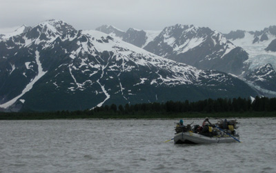
Alsek River 2014
Day 10, Thursday, July 3
 I recall writing in my diary
this evening that it was yet another “What a day!” But not necessarily
in a lovely scenery kind of way. We slept in until 6:30 am, which is
really decadent. We had another great breakfast of French Toast. Susie
loved the toast so much that she even wrote down the brand of bread
that the guides were using. Anyway, we packed up after breakfast, and
as we were loading the boats, we could tell that weather was coming
in, as the cloud deck seemed to be getting lower and lower. We
launched a bit after 10:00 am (it is only about 16 river miles to
Gateway Knob, our intended destination, so no big hurry), and it could
not have been more than 10 minutes on the water before the rain
started. Showers would come and go, but mostly, they stayed. And
increased in intensity. In a way, it was frustrating, because we could
see blue sky near the head of the Novatak Glacier to our north, but
the way we were heading, it was more rain and fog. We stopped after
about 12 miles of river running (probably less than 90 minutes), and
took a short hike across a peninsula so that we could take a look at
the upper reaches of Alsek Lake. If it had not been raining and foggy,
I probably would have taken my camera. But I regretted not doing so
once I saw the spectacular display of wildflowers on this little
projection of land.
I recall writing in my diary
this evening that it was yet another “What a day!” But not necessarily
in a lovely scenery kind of way. We slept in until 6:30 am, which is
really decadent. We had another great breakfast of French Toast. Susie
loved the toast so much that she even wrote down the brand of bread
that the guides were using. Anyway, we packed up after breakfast, and
as we were loading the boats, we could tell that weather was coming
in, as the cloud deck seemed to be getting lower and lower. We
launched a bit after 10:00 am (it is only about 16 river miles to
Gateway Knob, our intended destination, so no big hurry), and it could
not have been more than 10 minutes on the water before the rain
started. Showers would come and go, but mostly, they stayed. And
increased in intensity. In a way, it was frustrating, because we could
see blue sky near the head of the Novatak Glacier to our north, but
the way we were heading, it was more rain and fog. We stopped after
about 12 miles of river running (probably less than 90 minutes), and
took a short hike across a peninsula so that we could take a look at
the upper reaches of Alsek Lake. If it had not been raining and foggy,
I probably would have taken my camera. But I regretted not doing so
once I saw the spectacular display of wildflowers on this little
projection of land.
When we got to the edge of the lake, it was so foggy that one could barely make out the icebergs floating up against the shore. Disappointing to say the least. After returning, the guides made lunch, and we all ate wet, semi-soggy sandwiches while we listened to Sam discuss the rest of the day. Now, things were about to get “interesting,” and such requires some discussion. If one were to look on a topo map, you might get the idea that from where we were beached (ca. 7V, 659280 E, 6569173 N), it would be a relatively straightforward approach to row the main channel of the river out into Alsek Lake, and then around the east side of Gateway Knob, to the southern tip of the island, where there are several good campsites. But that would be taking what has been called the route into the “Channel of Death.” Because of several factors (the manner which river water pours into the main lake, and the prevailing winds), if there are a lot of icebergs in the lake, they can be pushed up into the main channel, or a secondary one (tight against the NE corner of Gateway Knob, now known as Door #2). It is way too easy to head around the knob to the north and east, and be trapped by icebergs. The icebergs from Alsek Glacier (whose face is something like 6 miles across) can be big, and with global warming, can be calved into the lake at a worrisome rate, especially during summer. We learned that one Canadian group got stranded taking this route, had to be rescued by helicopter and had to burn their rafts.
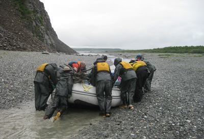 Even though the fog could be
thick at times, it would also dissolve and even from far back, we
could tell that the main channel was jammed with icebergs. We pulled
in on river right, and Sam, Thirsty, and a couple of clients scaled
this big scree slope to get a “bird’s eye view” of the situation. Back
in the water (I was in Sam’s boat and Susie in Joe’s), we started down
a small rapids toward “Door #2.” But Sam really had no intention of
taking that route. Instead, we beached the rafts and Sam walked off
into the fog, along with Thelonious and DB, to scout “Door #3,” the
west side of Gateway Knob. Sam soon returned without DB and his son,
and reported: “Well, there are some pools, but we will have to drag
the rafts between the pools.” I thought to myself: “Boy, this ain’t
gonna be easy, since, while we have eaten most of the food carried
down the river, the loaded rafts are still going to weigh well north
of 1000 pounds.”
Even though the fog could be
thick at times, it would also dissolve and even from far back, we
could tell that the main channel was jammed with icebergs. We pulled
in on river right, and Sam, Thirsty, and a couple of clients scaled
this big scree slope to get a “bird’s eye view” of the situation. Back
in the water (I was in Sam’s boat and Susie in Joe’s), we started down
a small rapids toward “Door #2.” But Sam really had no intention of
taking that route. Instead, we beached the rafts and Sam walked off
into the fog, along with Thelonious and DB, to scout “Door #3,” the
west side of Gateway Knob. Sam soon returned without DB and his son,
and reported: “Well, there are some pools, but we will have to drag
the rafts between the pools.” I thought to myself: “Boy, this ain’t
gonna be easy, since, while we have eaten most of the food carried
down the river, the loaded rafts are still going to weigh well north
of 1000 pounds.”
It turns out that DB and Thelonious had stayed behind to start pulling deadfall out of the water that was blocking the entrance to the first pool, working their asses off and both getting very wet. By the time we arrived, they had pulled most, but not all of the debris out. Ultimately, we tied a big line on to one of the snags and several of us pulled and were able to dislodge it. So, then, Sam’s boat, sans people, was floated into the first pool. Typically, the guide whose boat it was paddled and another guide, pulled the raft with a rope through the pool. At some places, the pools were not as wide as the raft, and then such required a more creative approach to lifting the raft through the maze. At some point, a pool would stop, and so we would all (at least 10 – 12 of us) would get a grip on the raft, and try to slide it a couple of feet over the gravel between the pools. As I write this more than 6 weeks after the fact, I can still hear Thirsty giving his chant: “One, Two…. Three… Pull!! One… Two….. Three…. PULL!!” At some places, this required a push as well. Eventually, we got the first raft to a spot where there was just water which could float the raft. Then, it was time to hike back to the north end of the Knob, and start the entire process with the second raft, etc. Gateway Knob is a little over a half mile from end to end. I would estimate that this process went on for at least half the total length of the knob, perhaps a bit more. I know Joe would give me a hard time paying so much attention to my watch, but I could not help but look: the entire process, once we entered the first pool with the first raft, until we got all three rafts clear, took 100 minutes. Not too bad.
A note: I would later learn a few days later, from a Park Service Ranger, that we were lucky, simply because the water level was up. The first group down the Tatshenshini/Alsek this year, a Canadian group, had lower water, no pools, and it took them two days to portage around the Channel of Death via the route we had taken. TWO DAYS!! Now, I understood why Sobek had planned a “layover day” at Gateway Knob. One needs to have some pad in the schedule in case of a big portage around the Channel of Death, so as to maintain the schedule at the take out point. (I have read that such is how these trips are scheduled regarding permits: the date of the take out. You miss that date and it costs you.
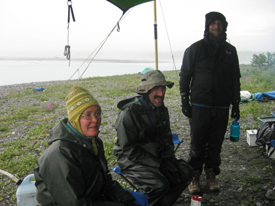 Back in the rafts, it was an
easy row around the south end of the Knob to our camp site (7V, 661152
E, 6563950 N). We saw another party at one of the other campsites,
probably 400 or more yards away, in red rafts as we approached. But
there was so much fog and gloom that I did not focus much on that, but
rather, getting our tent set up without it getting too wet in the
continuing rain. Fortunately, we had a very short break (ca. 15
minutes) and were able to get it up. Of course, that did not dry out
all the wet sand with which we were dealing. The ginormous tarp was
next, and just being able to sit down, out of the rain, was great. One
of the guides pulled out a bottle of Jim Beam. I helped myself and I
must say, my attitude improved. I need to remember something similar
to that for the next river trip. The Chambord is too much like
dessert. Dinner was served rather late (9 pm) as it ended up being a
long day. We had some sort or Thai food. It was good, but I don’t
remember much about it. Susie and I went to bed around 10:30 pm. It
was still rainy and foggy.
Back in the rafts, it was an
easy row around the south end of the Knob to our camp site (7V, 661152
E, 6563950 N). We saw another party at one of the other campsites,
probably 400 or more yards away, in red rafts as we approached. But
there was so much fog and gloom that I did not focus much on that, but
rather, getting our tent set up without it getting too wet in the
continuing rain. Fortunately, we had a very short break (ca. 15
minutes) and were able to get it up. Of course, that did not dry out
all the wet sand with which we were dealing. The ginormous tarp was
next, and just being able to sit down, out of the rain, was great. One
of the guides pulled out a bottle of Jim Beam. I helped myself and I
must say, my attitude improved. I need to remember something similar
to that for the next river trip. The Chambord is too much like
dessert. Dinner was served rather late (9 pm) as it ended up being a
long day. We had some sort or Thai food. It was good, but I don’t
remember much about it. Susie and I went to bed around 10:30 pm. It
was still rainy and foggy.
Additional Photos and videos can be found here: The Alsek Days 9 - 12 album on our SmugMug Photo Album Site
You might enjoy reading a different perspective on this same trip: Sarah Boomer's Report on the Thermophile.org website
© Roger A. Jenkins & Suzanne A. McDonald, 2014, 2016