Alsek River 2014
Day 3, Thursday, June 26
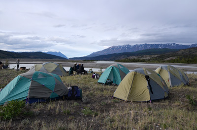
 Sam had announced the night
before that we wanted to be on the move sooner rather than later.
Coffee call might be as early as 5:30, and breakfast would be as soon
as the guides could get it ready. Susie and I were up at 5:15 and
started packing up our gear. One thing we should have brought with us
was one of our nylon ground cloths that we use for our backpacking
tents. Such would have provided a sand-free zone for packing gear and
they weigh little. Next time……
Sam had announced the night
before that we wanted to be on the move sooner rather than later.
Coffee call might be as early as 5:30, and breakfast would be as soon
as the guides could get it ready. Susie and I were up at 5:15 and
started packing up our gear. One thing we should have brought with us
was one of our nylon ground cloths that we use for our backpacking
tents. Such would have provided a sand-free zone for packing gear and
they weigh little. Next time……
Breakfast of eggs, wonderful bacon, and English muffins was served at 6:30 am. I was looking around, thinking about how much work it takes to put on a decent meal for 14 people out here. The guides use a propane stove for the actual cooking, unless it is a Dutch oven in the fire. The wood fire is for heating water for drinking, dishwashing, etc. But every morning and evening, the wood fire has to be started, run, and then taken down and the ashes scattered. Lots of work.
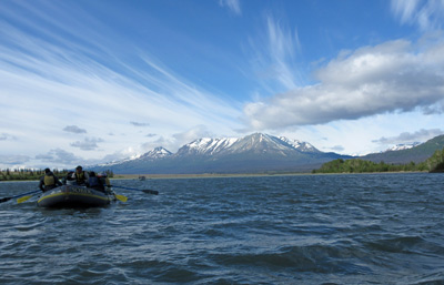
 The wind had died down overnight. But by 8
am, you could feel it picking up again. Not as brutal, but still
picking up. Camp was taken down, the rafts loaded and we were off by
8:15 am. I was impressed. The water was choppy, but not as many
whitecaps. It was a pull to get the last half-mile or so to the
confluence with Kaskawulsh River. It appears to be much larger than
the Dezadeash, and one can see on both satellite photos and from the
raft that the big challenge at the confluence is picking out the
correct braid of the river, because getting stuck as the braids peter
out would be no fun, for sure. But have no fear: as usual, the guides
were super. Susie and I were in Joe’s boat, along with Jim and MJ.
Once we got through the 2.5 miles or so of braids, things start moving
along nicely. Yes, there was still wind, but the current, with the
added flow and drop of the river, seemed to counteract the wind, and
it felt as though we might actually get down the river.
The wind had died down overnight. But by 8
am, you could feel it picking up again. Not as brutal, but still
picking up. Camp was taken down, the rafts loaded and we were off by
8:15 am. I was impressed. The water was choppy, but not as many
whitecaps. It was a pull to get the last half-mile or so to the
confluence with Kaskawulsh River. It appears to be much larger than
the Dezadeash, and one can see on both satellite photos and from the
raft that the big challenge at the confluence is picking out the
correct braid of the river, because getting stuck as the braids peter
out would be no fun, for sure. But have no fear: as usual, the guides
were super. Susie and I were in Joe’s boat, along with Jim and MJ.
Once we got through the 2.5 miles or so of braids, things start moving
along nicely. Yes, there was still wind, but the current, with the
added flow and drop of the river, seemed to counteract the wind, and
it felt as though we might actually get down the river.
We stopped for a brief “bio-break” near some rock outcroppings, and it was good to get a few feet above river level, in addition to giving our legs a stretch and our bladders some relief. One could look around and see wind blown sand in places. We got back in the rafts and continued on toward our lunch stop, landing about noon time. Sarah indicated that it felt like she had camped at this spot before (could this be Lava Creek?). It definitely was a nice spot, with a lovely creek coming in (clear water) and nice flat potential campsites. Anyway, a bunch of us wandered around, taking photos of the creek and other things, like very large grizzly tracks, while the guides made a nice lunch of tuna fish salad.
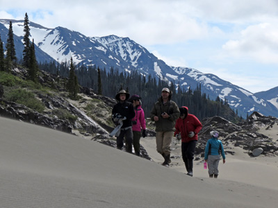 After lunch, it was back in the
rafts, for a bit before we stopped at the Alsek Sand dunes.
Interesting spot, but of course, one would not be surprised that there
would be a LOT of wind in this area. Elsewise, why the sand dunes. We
climbed around and took photos. Thelonious had to work off some extra
energy, I guess, so he would run up to the abrupt edge of one of the
dunes and leap off. I guess it must have been fun, but it seemed to me
as just an improved way to get way more sand into one’s clothing. Ah,
the difference between 15 and 66……
After lunch, it was back in the
rafts, for a bit before we stopped at the Alsek Sand dunes.
Interesting spot, but of course, one would not be surprised that there
would be a LOT of wind in this area. Elsewise, why the sand dunes. We
climbed around and took photos. Thelonious had to work off some extra
energy, I guess, so he would run up to the abrupt edge of one of the
dunes and leap off. I guess it must have been fun, but it seemed to me
as just an improved way to get way more sand into one’s clothing. Ah,
the difference between 15 and 66……
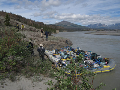
Back in the rafts, we made a few stops to gather some wood for our fires, since it was expected that there would be little wood at our campsite. To gather wood, the guides pull into a promising spot, everyone gets out of the rafts and scatters, picking up certain size pieces (not too big, perhaps as large in diameter as one’s wrist) and carrying them back to a set of straps laid out by the guides. Ultimately, the rafts go down the river with large stacks of driftwood tied to the front and rear (opps, bow and stern). Looks strange but it works.
 After the wood pick up stops, we pulled in
just downstream from (I think) Marble Creek. The guides did not tell
us specifically where we were but the GPS does not lie, and with some
topo maps at home and satellite photos, one can figure these things
out. Specifically, camp #3 was at 8V, 344912 E, 6702545 N. It was
still breezy, and I noted that our campsite did not have a lot of wind
protection. However, the tents were built for this kind of thing, so
we would be fine. Anyway, it was a bit stark, not very many trees, and
it was a long way to water for bathing. We made 15.8 linear miles
today. Roger B. said it best - if we were backpacking, we would set up
camp in a wind shelter near the creek. But with so much gear to move,
such is not practical. Nevertheless, Susie, MJ and I hiked the 300
meters or so to the creek, and cleaned up a bit. MJ put on a long
underwear top identical to mine. I commented as to such and he said
something to the effect that every trip he goes on, SOMEONE comments
that they have a top just like his. He was thinking that maybe, just
maybe, he had made it to this one without a similar comment. Well, no
such luck.
After the wood pick up stops, we pulled in
just downstream from (I think) Marble Creek. The guides did not tell
us specifically where we were but the GPS does not lie, and with some
topo maps at home and satellite photos, one can figure these things
out. Specifically, camp #3 was at 8V, 344912 E, 6702545 N. It was
still breezy, and I noted that our campsite did not have a lot of wind
protection. However, the tents were built for this kind of thing, so
we would be fine. Anyway, it was a bit stark, not very many trees, and
it was a long way to water for bathing. We made 15.8 linear miles
today. Roger B. said it best - if we were backpacking, we would set up
camp in a wind shelter near the creek. But with so much gear to move,
such is not practical. Nevertheless, Susie, MJ and I hiked the 300
meters or so to the creek, and cleaned up a bit. MJ put on a long
underwear top identical to mine. I commented as to such and he said
something to the effect that every trip he goes on, SOMEONE comments
that they have a top just like his. He was thinking that maybe, just
maybe, he had made it to this one without a similar comment. Well, no
such luck.
After clean up, a bunch of us sat around jawing, waiting for dinner. It was served at 8 pm, and well worth waiting for: baked salmon, a rice dish, and another great salad. No shortage of fiber on this trip, for sure. Anyway, dishes were cleaned up and most of us were to bed by 9:45. It had been a good day, getting some miles under our belt.
Additional Photos and videos can be found here: The Alsek Days 1 - 4 album on our SmugMug Photo Album Site
You might enjoy reading a different perspective on this same trip: Sarah Boomer's Report on the Thermophile.org website
© Roger A. Jenkins & Suzanne A. McDonald, 2014, 2016