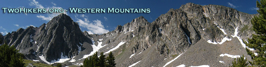
Beartooths Backpack 2002
The Best Laid Plans...
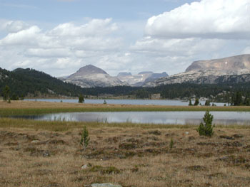
Island Lake Trailhead to T Lake
Saturday, August 31 Susie and I must have been up shortly after 5 am, our internal alarms forcing us to focus on the task at hand. As we were completing our final packing in the living room of the cabin, Susie commented that she was feeling a bit apprehensive, just like she always does before a long backpack. I often have a somewhat uneasy feeling, probably because I am facing a week of the unknown, but not this time. I had already been in the general areas in which we would be hiking, so felt pretty comfortable. And the weather forecast looked pretty good for the next several days, with only a small chance of scatter showers in the afternoons, pretty typical of the mountains. But there was not much time to get apprehensive, since Susie and I were "hosting" a communal breakfast in our cabin, brewing coffee and toasting bagels as fast as we could. Lance reported he had gone looking for us after he got in, and not finding us (he must have passed us walking back to the motel) at MacKenzie River, he found another place for dinner. We had the two mini-vans and one shuttle car loaded up, and pulled out of the parking lot just a couple of minutes after 7 am. We had decided to leave a half hour earlier than originally planned since this was Saturday of Labor Day weekend, and we expected slow moving crowds as we worked our way across the northern edge of Yellowstone toward Cooke City.
 Our first stop was in Gardiner, MT, right outside the north entrance to the park. In addition to hitting the head, we thought we would leave a copy of our itinerary and list of participants with the Forest Service Ranger Station. You have to look at the map for a bit to realize why this makes sense, since Gardiner seems a long way from where we would be hiking. In fact, it is the Ranger Station that manages the District in which most of our trip would occur, or so we thought at the time. Despite a wrong turn (or rather no turn, when there should have been one), Sue, driving Lance's van so that Lance could sleep, was just a few minutes behind us when we pulled into Cooke City. (We had at least caught a glimpse of a wolf in Yellowstone.) CC was a happening place this morning, I guess as it is THE jumping off spot for the western end of the Beartooth Highway. While we gassed up, Lance wandered off. I asked him where he was going, and he said he was looking for maps. While it seems pretty trivial as I write this now, I just blew up. When I asked him what happened to the digital maps that I had sent him (like I had with everyone else on the trip), he admitted that he had not started to work with them until the night before he left, and could not figure out how to chop them up into smaller pieces so his printer could deal with them. So he was going off to see if he could find some maps similar to the ones Andy had purchased the previous day in Barrel Mountaineering. I found him about 20 minutes later in the General Store (with the maps he sought). I mentioned something of the need to speed the process up, since I wanted to get started hiking before lunch time, since we had a substantial hike ahead of us. He looked at me a bit dumbfounded, and indicated that he thought we would be driving until about 2:30 pm. I snapped off something about his obviously not having looked at the trip itinerary that I had provided nearly a month ago, and stormed out of the store. I guess I was pissed, because of all the work I go to in the planning, and getting information to people (I had even offered to provide anyone who wanted with a complete set of aerial photos of the route) way ahead of time, and he obviously had not absorbed or cared about much of what I had sent. But as I said, it seems merely annoying now, a month or so later. I confess to having a bit of the Drill Sargent mentality as I try to get the troops to the trailhead, and squandering time, when I thought we could have a fairly long afternoon, was not what I wanted to do.
 We were out of Cooke City about a half hour after we pulled in, and in another half hour, were putting our shuttle car at the end of the trail where we planned to exit, off the "Goose Lake" road. We got one of the last parking spots, an indicator of how popular this place can be. We were treated to a procession of what our friend Ray derisively refers to as cockroaches (ATVs) topped with grossly overweight people as we tried to pull out of the parking area. We all commented that we were glad to be getting into truly roadless country in another hour or so. From that trailhead, it was about a 40 minute drive to Island Lake. I could just feel Tim roll his eyes as we pulled into the overflow parking lot, and get the last two possible places to park a vehicle. I assured him that this was just due to it being Labor Day weekend, and that I was certain that by this evening, we would have all the solitude we wanted. We gobbled leftover pizza from MacKenzie River, threw on our packs, and pulled out of the parking area at 11:54 am. We were finally underway.
What a spectacular place to start a trip: Island Lake is the last of a chain of lakes nestled in a very broad, shallow valley. You can see the mountains in the distance, but you are just below timberline, so you feel like you immediately step out into the "good stuff," without having to climb through miles of forest. Of course, there was this little thing about the weather. 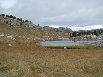 Ever since we had left Bozeman, I had felt like I was outrunning a bank of clouds moving in from the west. Since we had stopped moving to the east, the cloud bank was starting to catch up. But cloud bank or no, it felt great to be out here. We were following the Beartooths High Lakes trail around the west sides of Island and Night Lakes. The terrain was flat, just what I, with my 70 lb pack, needed to get rollin' and get some miles under my belt before I had to do any serious climbing. Of course, with 70 lbs, a hundred foot hill can be pretty serious. As we started to climb beyond what some maps call Flake Lake, we could hear thunder in the distance, and so we all stopped to don rain gear and pack covers. The sky was looking pretty black. A group of exiting Boy Scouts (few of them carrying enough of the Ten Essentials, by the absence of day packs) warned us that it might get bad out here. I tried to say something about having the right kind of gear, but I think the point was lost on them. The sky was getting pretty black and it looked like we were going to be clobbered. The rain started as we began our descent to Beauty Lake. I am sure it is lovely under most circumstances, but right now, my primary goal was to stay dry, and keep moving. Crossing the inlet stream was a mere rock hop (I had looked for an easier spot, and couldn't find any). Past Beauty, we started our climb back up into woods. Nice and steep, but fortunately, short. The rain had quickly stopped, and most of the crew was stopped at a crossing of another of Beauty's inlet streams. It seemed a good time to take a chance and stip off the rain pants. I really hate backpacking in rain gear. You get overheated in almost any circumstances, despite all the vents, flaps, etc of the fancy jacket I was wearing.
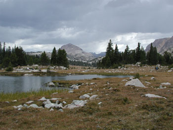
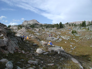 About a kilometer past the second inlet of Beauty Lake, the terrain starts to open up, and you are in that lovely near-timberline zone. By the time it gets to Claw Lake, life is really good. The rain had stopped for us, but it was pounding fellow hikers to the south. You could see the showers pass in waves. I felt like we were moving along at a pretty good clip but as usual, everyone else was ahead of me. That is fine, as long as those in front are looking at their maps. Near Marmot Lake (these names are from the maps published by Rocky Mountain Surveys), the trail makes a huge 180 degree bend as it climbs up a hill. While I had not been over this section before (in ‘85, Sunny, Earl, and I had followed the first drainage all the way to Albino Lake, a great - and easy - XC route), I knew to pay attention in this area, because it was about time to leave the maintained trail and head up the drainage, first to the outlet of T Lake, and then up to Lonesome Lake. I yelled ahead to Susie not to go any further on the trail, and she knew right away to what I was referring. She noticed a ramp-like feature that could take us from the trail forward toward T Lake, so I got on it, with her immediately behind me. I figured the rest of the group would see what I was doing and take the hint. Susie and I slowed down to let the others catch up, and they reported that Andy had pretty quickly realized that climbing 180 degree turn was not part of today's planned route. I thought the footing was pretty good, as we gently climbed toward T Lake, but then I heard a "Shit!" and a thump behind me, and I turned around to see Tim sitting on his butt with his foot in a small depression. I asked him immediately if he was OK, and he did not answer right away. Still feeling things out, but never a good sign. We helped him up and he reported that his ankle was quite sore but probably ok. I kinda looked around at everyone, and the eyes told me that maybe somewhere closer than Lonesome lake (which was still about a mile and 250 feel of climbing away) would be a good place to spend the night. Sue and I dropped our packs and began to scout a small draw just to the east of the south end of T Lake. Hey, it had water not too far away, it had some flat places to camp ...... It looked like "home for a night" to me. (Camp would be at 610091 Easting, 4982844 Northing.) I could see that Tim was favoring his ankle big time. I was glad that we were stopping. One advantage of the particular spot we had picked was that it featured nice rock faces on either side of our camp - perfect for hanging food out of the reach of grizzly bears. This, was after all, the grizzly side of the Beartooths, and it never hurts to be prudent. We all scattered a bit, looking for available flat spots not in the water course. Susie and I picked one, and hurriedly erected our tent, as we could tell it would not be long until another downpour hit. We had just got the tent up, threw in our gear, and dove in behind it as the rain hit.
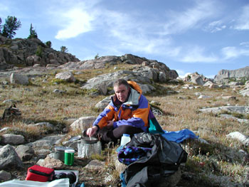 Susie and I sat in our tent, putting on some PolarTek, as you could just feel the bottom drop out of the temperature. We peeked outside and saw that the rain had "solidified" a bit. We recalled back at having to do something similar on the last full day of our trip in the Sierras in 1998, except in that case, we were soaked and very very tired. I looked at my watched and was amazed to see that even with the frogging around, we had made the 7 miles to this camp in about 3.5 hours. Pretty good for big packs and 9500 feet + elevation. Somewhere around 4:15 or so, I decided to venture out and check out the bathing possibilities. I know, the concept of bathing when we have just endured a hailstorm may not be appealing to many, but we were only 1 day into an 8 day trip, and .... well, cleanliness is next to ... and all that other stuff. Besides, the storms were tracking a couple of miles to the south of us, and I saw it as my big chance. I could also go down and get some water. I walked down the drainage to intercept the outlet from T Lake, and did my thing, grateful that the showers were not raining on my parade. By the time I got back from bathing and doing laundry, it was time to start thinking about dinner. In fact, the non-bathers had already picked out a dining area, and the clouds were starting to thin. A lovely partly cloudy evening was on tap, with lots of alpenglow, and rays of sunshine, and patches of blue. Dinner for Susie and I was Cajun Beans and Rice. After hanging our food on the face of the rock walls, we gathered again and stayed up to just a little past sunset. I am not sure if everyone was tired or cold, but the party started to break up a little after 8. Maybe we all just wanted a good night's sleep.
© Roger A. Jenkins, 2002