Beartooths Backpack 2002
The Best Laid Plans...
T Lake to Martin Lake
Sunday, September 1
 What a gorgeous way to start a new month. It had been a cool evening, with temps slightly below freezing, judging from frost on the stuff left outside. There were still some clouds, but the night had been remarkably dry. It had also been breezy (you don't call it windy in the Beartooths until you are looking at a gale), and there was little dew. Remarkably, the tent was totally dry as we packed it up. The only thing that had not survived the night was Tim's towel. He had left near the cooking area, and had a huge hole chewed into it. Some critter has a lot of new, comfy nest material. We checked with Tim to see how his ankle was doing, and sore but walkable would have been a pretty good summary. So we decided to do a modification in our route. Originally, we had planned to go from Lonesome Lake ( a mile or so away, and XC hike to the northwest, eventually coming in near Heart Lake, and pick up the trail over to Martin. But Tim, I think rightly so, felt like we ought to stay a) together and b) as much on trail as possible. No dispute there. So we decided (I had studied this the previous evening in the tent) to backtrack, pick up the Beartooths High Lakes trail, and hike on trail to Wright Lake before going over to Martin. Since tomorrow was planned as a layover day, it would give his ankle a couple of days before tackling any major cross country work. So we pulled out of camp about 9:20, dropping down the drainage about 0.6 miles, and turned up the draw toward the "official" trail, planning on leaving it briefly as it makes its big bend to the south, before it turns back north. Essentially, we turned NW, leaving the trail, and headed across easy terrain and open country, arriving at a high spot just east of where the trail from Clay Butte hits the High Lakes Trail. (We think the map is mis-marked and the trail comes in nearer the 10,000 foot level, but I did not bother to take a GPS reading, since it was still pretty, ah ... breezy.) Back on trail, we began our first of many, many descents that day, coming into the SE corner of Native Lake, where we saw our first party since about 1:30 pm yesterday. If this passes for "crowded" in the Beartooths, then we love it. We stopped for a rest break. Tim's foot was doing ok. In fact, it only slowed him down to the point where the rest of us could keep up with him. We left Native about 10:55 am, and felt like we were on a roller coaster for the next several hours. The trail is skirting the edge of the plateau, cutting across drainages, and the only way to do that is to gain and lose elevation. Whew. The route descends to the outlet stream of Hidden Lake, about a half a mile downstream of that lake at about 9327 feet. It was nice to take a break for lunch, but counting all the remaining ups was depressing. I just did not seem to have much energy this day, which for me is pretty common for me on my second day at altitude, but I felt especially draggy this day.
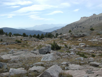
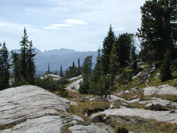
 We left lunch about 12:55 pm, and began our after-lunch climb. I always try to eat less before the uphills, but I was hungry today, and knew I would pay. As the trail continues to skirt the edge of the plateau, the ups and downs keep coming. Eventually, you get to a nice, really steep, punishing uphill. Feels like you are in an elevator. We took a rest break and Sue asked me how I was doing. My usual answer for these things is "Slow, but I am getting there." Susie had been very patient with me all day: just waiting at the top of climbs until I caught up. I don't think I was ever more than a few minutes behind, but it always seems longer. We had run into a couple in their late 40's or so earlier in the day (we saw several parties over the course of the day), that were unsure of where Granite Lake was. Now Granite Lake must be, like, one of the biggest lakes in this part of the Beartooths. How you "lose" it is not clear to me. I think their problem was that they were out hiking without maps. Another mystery. Being out in the wilderness without the ability or material to read a map can be shear folly. Now maybe someone who had a bear steal his pack with all his maps in it has an excuse, but that it about it. It wasn't more than ninety minutes after lunch that we ran into a couple of young women, one of whom worked in Yellowstone. They had a wonderfully well behaved and friendly dog with them, but they were a little "confused" as to exactly where they were. They seemed to be using an old Forest Service map to route find. About a third of an inch to the mile. Simply amazing to me. Your map is your lifeline. Oh well, who cares, as long as I did not have to go searching for them. It was such a glorious day, with lots of blue sky, a few clouds and views to die for off the west into Yellowstone, and to the Beartooth crest, that despite all my huffing and puffing and lack of energy, it was beautiful.
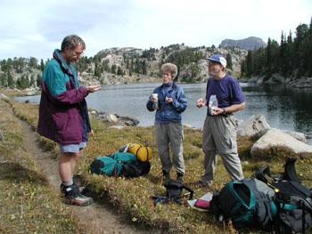
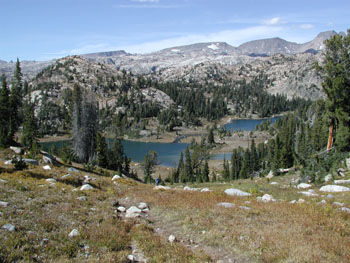
 We topped out last rise, and looked down into what might be called Organ Lake Basin: Heart, Liver, and Kidney, and scratched our heads at the map makers. We could see the trail winding around to first our left and then our right, eventually skirting within a few feet of the western shore of Kidney Lake. But the map showed it in a totally different location. Since it was pretty clear as to where we were heading, I did not much care, but in thick fog, it could be pretty darn disconcerting. Another good reason to carry a GPS. Anyway, as one goes to the NW of Kidney, you are hit is the face with the drop dead view down into Martin Lake Basin. The guidebook calls this the most beautiful lake basin in the Beartooths. I am never one for casual hyperbole, but it surely is lovely. Especially when you know you don't have to move camp the next day, and the weather is looking better all the time. Not even a rain shower this afternoon. The drop down to the basin was a bit steep, and there really is no "official" trail around the east side of Wright Lake, but the going is very easy. As we pulled into the lower end of Martin Lake, it looked to us like some good camping nearby, so we blew off hauling our butts and pack up to the NW end of the lake. It was 3:45 pm, and we were home, for a couple of nights.
 Now finding a good sheltered spot to put up the camp in the "breeze" took a bit of doing, and we stretched out over perhaps a hundred and fifty meters of real estate. God, I was tired. Everyone else seemed to be in a tired mood. Even though there had only been one steep climb today, the series of little climbs had probably pushed our total elevation gain to nearly 2000 feet. I was not convinced that the on-trail approach for getting here had been any better for Tim's ankle, given the rockiness of the trail, but Tim was graciously appreciative. Susie and I found a spot to take a bath, somewhat sheltered from the wind - oops, breeze, that still had a bit of sun on it, but when she opened her personal kit for the first time (she really had not taken much of a serious clean up last night, she found that she had mistakenly packed hair conditioner rather than shampoo. Boy, was she pissed. And of course, it was my fault somehow. I think she just lacked a dog to kick. But in the mountains, her bad moods don't last very long: life is too good. I noticed that my throat was getting a bit sore, and I felt a bit cooler than I might have otherwise. I wondered if maybe the onset of a cold had been responsible for my lack of energy today. At any rate, dinner was in order, and so we searched for a spot to get out of the breeze. Ok, it was pretty damn windy. I thought I had noticed a couple of whitecaps out on the lake. After we figured out where to hang our respective sets of food bags (my nearly falling off a huge dead log did not deter our search for the perfect branch), we decided to cook dinner on a little knoll that had some trees on it. The way the wind was blowing, there was not a whole lot of choice. I think we had dinner going by shortly after 5 pm. Susie and I cooked up a mess of Beef Stroganoff (the Hamburger Helper version makes a lot, and it is pretty tasty, especially when fortified with freeze dried beef and dried mushrooms). We chatted for a bit after hanging our food, but we were all fairly well bushed after the day. I found some solace in that, given the fact that all these other strong hikers were tired after what looks on the map like a pretty short day (something like 6.5 miles or so). The evening was lovely, but by 8 pm, bed sounded like the best option.
© Roger A. Jenkins, 2002