"Iffy" on the Continental Divide: Return to Colorado's Weminuche
Out
Friday, September 23
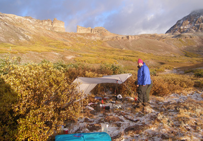 It turned out to be a rough night. The kind of night that forces one to acknowledge one's insignificance in the face of Mother Nature. The kind of night that has you staggering as you emerge from the tent, merely happy to see the sun again.: We were hit by wave after wave of thunderstorms. Snow, rain, and lightning. The lightning strikes were disconcertingly close. I estimated some to be 200 - 300 meters away. When you are exposed like we were, one is just happy to have survived. We emerged from our tents to much colder weather. All the snow and rain had frozen on the tarp that we had dropped to the ground so it would not blow away. When I started preparing the breakfast area, I tried to lift the thing and thought twice: it must have weighed a hundred pounds. So first, we had to bust up the ice and dust off the snow before we could erect the tarp. Tim reported he had gotten very little sleep, and Diane reported her guts were not good. Acid reflux, or something. Tim was also "stopped up." In contrast, I had just been scared shitless. OK, maybe not that bad, but I confess to some degree of concern when lightning is crashing all around one and there is really no place to hide.
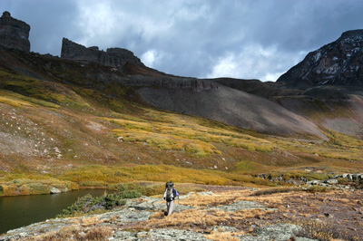 With some effort, we pulled out of camp at 8:45 am, and followed the CDT. But of course, we were not hiking where the trail shows on the map, but much further upslope in the flats north of Opal Lake. It is well over a mile NE of Opal Lake before the actual trail and the CDT as marked on the map merge. We kept looking for a trail junction with the old CDT trail, that climbs out of Weminuche Pass closer to the Divide, and comes into these same flats north of Opal Lake. We could see it doing a climbing traverse along the south facing slope of the ridge that is crested by the Divide. This was the trail Sunny and I had taken 21 years ago. But no luck seeing a junction if one is headed southbound (but physically north) along the actual CDT. So if you are heading in this direction, pay attention and be willing to do a bit of route finding.
Within a few hundred meters after the CDT actually begins to drop down into the Rincon la Vaca (Valley of the Cow), we came across a lovely spot. Grass, a small stream, a few scattered trees, and lots of flat places. It was only about 40 minutes along the trail from Opal Lake, and had we known of its presence, we probably would have pushed on, for the sake of a bit less exposure to the elements. Alas, the hiking guides do not mention it. I liked the spot so much I took a waypoint, and now share it with readers: 13S, 290956 Easting, 4172257 Northing. It certainly does not have the expansive views of The Window, or the surrounding mountains that the Opal Lake campsite did, but it does have a bit of protection, which we would have been welcomed. I guess finding little gems like these is one reason why I write up these trip reports.
 After this little spot, the trail began a very steep descent for the next 500 feet, after which the grade moderates substantially. This would be a very tough climb at the end of the day, if one was heading in the opposite direction. We stopped a few times, enjoying the sunshine for a change, to let Tim make what is euphemistically referred to as a "long distance call." Unfortunately, he was not able to make a connection, shall we say. The drugs had not kicked in yet. We had to work our way through what appeared to be an avalanche track, with a number of trees down and lots of brush, right as the trail makes a switchback above the small meadow through which it descends to Weminuche Pass. We spied a moose in the willows on the south edge of the meadow as we emerged from the debris field. Diane had started thinking about why her guts were hurting and recalled that in the past, she had a bit of a negative reaction to any iodine pills being used to treat water. That was one reason why she and Tim had switched to a filter. But in studying the filter instructions, Tim had the realization that their filter had iodine in it as a way of doing a "final kill" of any bacteria slipping through. So we dumped Diane's water and pumped some fresh stuff through our Pur (now Katadyne) Hiker filter, that does not use iodine.
We passed a couple of parties that had camped in this meadow. They commented from afar that it had been a rough night where they were. We exclaimed that it was likely worse up where we were. We arrived at the edge of Weminuche Pass meadows around 11:15 am, 2.5 hours after leaving camp. Not fantastic time to make the 4 miles or so, but considering the night we went through, and our various ailments (have not even mentioned my sorry-ass left knee), we felt like we were doing well. At this point, we turned north, and departed the CDT, heading for the trailhead at the east end of Rio Grande Reservoir. We stopped for lunch just a bit after the crossing of Weminuche Creek, enjoying the partial sunshine on a trip which had offered little of such. It was a bit breezy, but it was nice to not have impending rain hanging over our shoulders. Weminuche Pass is an interesting place. It is really a 2+ mile long by half mile wide meadow, that has a very slight slope to it on both the north and south ends. If you were not looking at a map, I don't think you would ever suspect that the Continental Divide splits the meadow in two, dividing the north and south halves. Great views, lots of camping, and not too far from a trailhead.
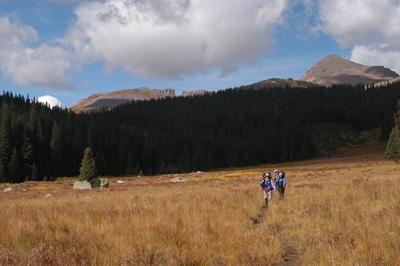
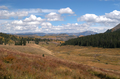 After lunch, we started to push. First, the hiking was easy and secondly, we were like the horses heading for the barn at night. We made a couple of miles in the next 75 minutes, and that included stops to take lots of photos of the sea of gold to the north. This was definitely the peak of the aspen turning. My father, trained in forestry and wildlife biology, claims that the aspen is the most widely distributed tree on the planet. A poster in one of the visitor's centers in Yellowstone shows concentrations of aspen across North America, and SW Colorado was clearly "aspen central." As we began dropping into the gorge at the north end of the meadow comprising Weminuche Pass, we encountered an additional unfortunate reality of hiking in this Wilderness Area: mud on the trails after any kind of a rain. We had encountered such before, and it is not fun. At least today, it was not raining. The problem seems to be with a) the large amount of horse use in the area (and horses have vastly more impact, in terms of pounds per square inch, on trails than that of backpackers) and b) the lack of water breaks to divert water off the trails.
The mile and a half from the mouth of the gorge back to the trailhead seemed to go on forever. Maybe it was just the extreme mud that either slowed us down, or made each step just SEEM longer. We actually got significantly ahead of T&D, and made it down to the trailhead about 3:20pm or so, or about 6.5 hours after leaving camp. I felt pretty good, seeing how we had covered a good 10 miles in that time. Certainly not speed hiking, but good progress. Maybe we were finally adjusting to the altitude. Susie and I went off to wash our hiking boots and lower pant legs off before we sat in ANYONE's vehicle. T&D showed up a few minutes later, cleaned their boots, and Tim and I hopped in his car to run the car shuttle. We were back to our ending trailhead and outta there by 4:20 or so, with only a 2.5 hour drive back to Pagosa Springs in front of us. It being Friday evening, we opted for take out pizza in Pagosa, and I reflected on our upcoming trip with Andy and Sue, scheduled to start on Monday, in Upper Dark Canyon. I kept thinking: well, since that area is desert, at least it should be dry. Little did we know .......
Additional Photos of this trip can be found here: The Weminuche Wilderness 2005 on our SmugMug Photo Album Site
© Roger A. Jenkins, Suzanne A. McDonald, 2005, 2007, 2017