Sierras 1986
Sequoia's Eastern Boundary
On to Sky Blue Lake
Sunday, August 31
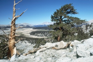 Another glorious day in the Sierras. Sunny and I were up before sunrise, not yet being accustomed to the time zone differential. Earl looked very snug, with only his sleeping bag between himself and the elements. I have read in hiking guides that a lot of Sierra backpackers hardly bother with tents, because the weather is so good so much of the time. I guess, having cut my backpacking teeth in the Appalachians, where it rains frequently on a moment's notice, it is hard to leave the shelter of a tent in your closet. We cooked breakfast, the usual granola or oatmeal fare, among scattered whitebark pines. It is interesting to me how the pines grow to such size, but there seems to be little understory, or even grass. Just large diameter - but short - weather beaten pines growing in ground up rock.
George and Earl took off, and Sunny and I were not far behind, although it always seems to take a couple longer to get going in the mornings that a single person. Coordination must have a lot to do with it. We planned to spend a good part of the day's walk on the Pacific Crest Trail, even though the concept for this trip - doing the eastern boundary of Sequoia National Park as close to the crest as practical, given our abilities - called for us to stay off it as much as possible. Steve Roper, in his book about the Sierra High Route, which is a higher elevation alternative to the John Muir trail, articulates the philosophy much better than I can. The general idea is one of avoiding the crowds, the chewed up trails and keeping out of the woods. The latter is of particular interest to me, since, if I want woods, I can always hike in the Smokies. I come to the West to get the big views, and the sub-alpine vegetation. All that said, sometimes there is not much of a practical alternative to the highway that is the PCT in this area, and even Roper acknowledges such. So down the highway we rolled. Actually, while the trail consists of much ground rock and sand in many places along the 5 miles or so to Rock Creek, we saw very few people. The trail itself skirts timberline much of the way, and the walking was not unpleasant. Expansive views of the mountains to the west, and huge relatively flat meadows or sandy areas kept our minds off our pack weights. Sunny was carrying both a tripod, a walking stick, and a fishing rod. She is a tough lady, but I thought her pack, which was probably pushing 50 lbs, was a bit much. The Kern River splits this country into two parts. The eastern escarpment has the highest and most dramatic peaks, but the Great Western Divide, which we could see to our northwest, was impressive. We could only get a small sense of the yawning chasm of the Kern River Canyon, noting the western side of its sheer walls. As we crossed the boundary between the Wilderness and the National Park, Siberian Outpost came into view and we all agreed that while it did seem desolate, it was certainly much more inviting than our imagined view of its namesake.
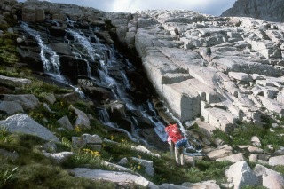
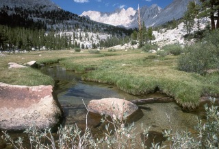 While we had read that there was little reliable water between Chicken Spring Lake and Rock Creek, supposedly 8.5 miles north of the lake by trail, we found water to be not too much of a problem, as we crossed a couple of nice creeks (maybe we are used to the small trickles in canyon country), and had lunch in a nice meadow about 4 miles north of the lake. A large horse party passed us, and it was one of the few groups we would see all day. At this point, we were near the 11,000 foot mark, and there was more of a sense of forest. After lunch, we continued the gradual descent to Rock Creek. While the hiking guide says it is a lot further, our sense (and subsequent digital mapping supports this) was that it was maybe 5 - 6 miles from the Lake to Rock Creek. Because of the elevation, we were feeling our 6 miles more than we would have in the eastern US, and we stayed pretty much within 50 meters of each other. At the point where Rock Creek intersects the PCT, just below 10,500 feet, it was time for us to leave the trail, and have some fun. I always enjoy off trail hiking in the western mountains. In many cases, it is surprisingly gentle, and of course, there are very few people. In this case, our route turned up Rock Creek, and pretty much followed it to its source. At first, there is pretty clear use path, especially where the valley tightens up, but as the floor broadens, it is a simple matter of picking your way up through lush grass and boulders. The route was pretty gentle in most places. That does not mean we were not feeling tired. The route starts at an elevation of 10,440 feet, and Sky Blue Lake, our destination for this evening, is at 11,550. So somewhere in the 3 miles of XC hiking, one has to gain 1100 feet, and while the grade seemed gentle, it tended to gain elevation in steps. There were several lovely cascades over beautiful granite shelves. Even though this was Labor Day weekend, there were still plenty of wildflowers. If only I had the energy to photograph them. We also noticed that the clouds were coalescing, which suggested a thunderstorm might be in the making, so we stepped as lively as the meadow walking and our packs would permit.
 It was late afternoon when we made it to Sky Blue, except the sky was dark grey. Sunny and I quickly erected our Sierra Designs Domicile, and took a quick bath near the lake shore. The wind was starting to pick up, and wet skin in the breeze encouraged me to move quickly. I just about finished my bath and the storm erupted, the thunder echoing around the partial cirque in which the lake sits. Actually resting for a bit inside the tent felt pretty good, and my sense was that the rain would not last too long. I was right, and in about a half hour we emerged, albeit with wool shirts and down jackets, as the temperatures had plummeted following the storm. We cooked dinner with George, but Earl was pretty much holed up in his tent - as we would learn later - vomiting frequently. It would not be a good night for him.
© Roger A. Jenkins, 1986, 2001