Sierras 1986
Sequoia's Eastern Boundary
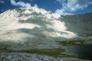
Ascent of Mt. Whitney
Wednesday, September 3
 I could feel Sunny stir at first light, and heard her and George having breakfast. I think they were pretty much gone by 7 am. I just laid in the tent, hardly having the energy to wish them good luck. I had no doubt that they would do it. I just wanted to be with them, but it was all I could do to turn over and go back to sleep.
About 10 am, the heat of the sun was beginning to make the tent uncomfortably warm, so I dragged myself out, and figured I needed to have something to eat. I munched on some granola, and stared up at Whitney, trying to figure out where they were at this time, and hacked up green globs of crap from my lungs. In the Smokies, a 3000 foot climb in a little 4 miles is steep, but certainly doable on a trail. Starting at 11,000+ feet, it is not exactly a stroll in the proverbial park. But given the fact that we had acclimated for a few days, I had every confidence they would make it. Here is their story, in their own words.......
|
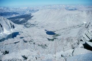
Sunny's Story: At the pass, we saw our first views of the scenery to the East. It appeared we were much higher as the valley was some 8000-9000 feet below. There were many large backpacks hanging there where people had left them. That was surprising to us as there were many ground squirrels, marmots, etc., that could invade them. There were a number of groups of hikers coming up from the East side, unlike what we had experienced so far. The John Muir trail followed the ridge line north to the summit, about 800 ft above the pass. The trail was rocky and narrow in spots but easy to find. Generally the mountain sloped gently off from the West side and was mainly talus. I do not remember many flowers from the pass on though there may have been. On the East, our right side, it was a sheer drop off for many thousands of feet. Mostly, the trail was just below the crest so we were not exposed. However, there were at least one or two places where the trail was only 2-3 feet wide with sheer exposure of thousands of feet straight down on the right (east) and a fairly steep drop off on the left (west). I had to focus on the trail and avoid looking off so as not to make a misstep. The air became noticeably thinner as we climbed and we slowed our pace, stopped more often, and used the rest-step to help our breathing. The temperature dropped so we added more layers. I don't remember much wind.
It was like a party that day, so high in the sky, knowing that we were at the top of our world. Everyone was so excited. People were laughing and cheering, eating, snoozing, photographing, and just sitting silently mesmerized by the place. A group of people from Texas were enjoying the bottles of beer each one had carried all the way from the valley to celebrate their accomplishment. I wished I had a glass of champagne to toast our success. On the far west end, there was a pit toilet built up like a throne with board walls on the North, east, and south sides. When you sat on it, there was this unbelievable never-ending view off to the West. I swear, it is the best "bathroom" in the USA. At one moment we heard an engine, looked up, and saw an Air Force plane refueling another plane right above us. Wow. We never wanted to leave it was so fantastic. After eating lunch, watching the marmots and ground squirrels, and relaxing for about an hour, we reluctantly began our descent. It was a piece of cake compared to the climb. We slept well that night, happy and very tired from the big day.
George's Story: Part way up, the trail coming up from the Bishop Trailhead came through a narrow pass from the east and soon there were other hikers heading up the trail. It is a well established challenge for strong hikers in the Sierras: Climb the entire 12 miles and 6000 feet from the Bishop Trailhead to the peak and return in one day. Some of those hikers seemed to regret having accepted the challenge, but many were still going strong when they reached the top. One lady seemed especially strong near the top. She was very large and tall, with a Scandinavian appearance that featured long blonde pigtails, and she had made the climb in record time. Near the peak, the trail degenerated into a scramble over large rocks. In fact, the entire, broad peak was a huge pile of rocks and all of the walking consisted of stepping from rock to rock. On the east side of the broad top, there was an area about ten feet higher that seemed to be the actual peak. From it, one could look almost straight down on the eastern side of the mountain where there was a brilliant green lake. About fifty yards west of that peak area was an old stone building that could have been a former weather station, and about 100 yards west of that was an open-air privy. The privy had a board partition that screened the user from the view of others on the peak, but the seat provided a magnificent view of the Sierra Range to the west.
After enough view savoring (and a visit to the throne/privy by Sunny) George and Sunny started back down. George was several hundred yards in front of Sunny when, about a mile or so down the trail he encountered the scruffy, field jacket guy. He was standing against the wall on the left and was pointing farther down the trail to a rock formation. He said loudly, and pointing with his stick, "There's the Tin Man below us!"
George said, "What are you talking about?"
By this time Sunny had arrived and she and George proceeded safely on down the trail. As they passed the next bend, Scruffy shouted across the void, "Do you go to Sunday School?" |
 Mt. Whitney was an exciting climb. We got up early. Roger was so sick with the pulmonary infection and cough that he was having a hard time breathing at 11,300 ft. where we were camped. I remember feeling so sad that he could not make this climb with us. George and I started out on the John Muir trail after breakfast I would guess about 6:30 to 7:00. It was a sunny morning and I felt good. I carried my red external frame backpack with hiking essentials, extra clothing, jacket, rain pants, lunch, and my camera on the tripod, I think. The trail from the back side of the pass was wide, well-maintained and it switchbacked gradually up the mountain. As we ascended, the views off to the West revealed beautiful lakes and tarns framed by the surrounding mountain peaks which we had not seen from the campsite. Our pace was steady and we rested at regular intervals.
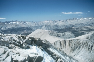
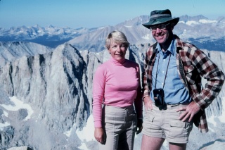 It was a thrilling moment to reach Mt Whitney's summit! It had taken about 4 hours to make the climb. We missed Roger. I know we were there by noon. The top was as large as a football field and relatively flat, with a 20-30 degree slope with the high point at the East side. It was mostly rocks with some larger boulders. There were so many people there that George and I were surprised. There was a brilliant blue sky, bright sunshine, and fabulous views of mountains in all directions. It was such an exhilarating feeling. It was difficult to breathe and I felt giddy and whoosy but not nauseated. It was hard to think straight. On the East, you could sit right "on the edge" and look down forever. There was a small low building with a ledger where you could sign your name and hometown.
 There were about twenty or thirty hikers gathered on the broad peak. People kept arriving and leaving, but once there, it seemed a shame to turn right around and go back. One should linger to savor the accomplishment, and the views from the highest peak in the lower 48 states. Several Air Force bombers flew over in the process of mid-air refueling and a former airman in the crowd mentioned that, at 14,496 feet, we were about half as high as the bombers. Two of the lingerers seemed to be having an argument about religion. The issues were not clear, but the discussion was heated. One man was especially strong voiced. He had a scruffy appearance with a two or three-day beard and a slightly tattered army field jacket.
Arriving safely back at Guitar Lake, Sunny and George found Roger feeling slightly better after a day of rest. The next morning he was well enough to continue the hike.
© Roger A. Jenkins, Sunny J. Woods, Geroge G. Ritter, 1986, 2001