Sierras 1986
Sequoia's Eastern Boundary
The climb over Crabtree
Monday, September 1
 Indeed, it was a very bad night for Earl. He indicated that his normal practice when going to the Sierras was to spend a few days at mid-elevations, to try to acclimate. On this trip, he had gone from essentially sea level at his home in Montecito to 11,200 feet at Chicken Spring lake, in one day. Yesterday, with 9 miles or so, and never having dropped below 10,000 feet, was more than his body could handle. He was experiencing classic symptoms of elevation sickness, including nausea and headaches, and he reported having slept very little last night. He felt that he had no choice but to abort the trip, because he felt that with the prospect of not being able to get down below 10,000 feet anytime soon, there was no way he could regain the strength necessary to do what lie ahead of us. Elevation sickness impacts people differently. I was tired, and noticed that my breathing was a bit more labored than usual at this elevation, but beyond the sore throat I seemed to have acquired, which I mentally wrote off to the cry climate, I felt pretty good. I hated that he was leaving us, because this former dean in the Cal State University system is both a strong hiker and a wonderful conversationalist. But I was not worried about him, and knew he would fend for himself the next few days just fine. His plan was to get to lower elevation, go out in a day or two, drive the minivan back to the Symmes Creek trailhead where he could pick up his vehicle and bum around until we were off the trail. (In fact, he ended up hiking all the way out in a day, and drove home to Montecito the next day, before returning later in the week to shuttle George back to LA, while Sunny and I went to Death Valley, the San Gabriel Mountians, and eventually on to Earl's home.)
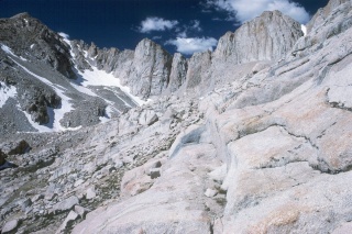 We were down to three of us, and we had a major pass (Crabtree) to cross. The weather looked lovely, and while we knew we would be off trail the entire day, we did not have many miles to cover. We began to skirt the east side of the lake on grassy meadow like areas. From our camp on the south end of the Lake, it had looked like there is a wall that one has to ascend to get to the lake below the pass. But looks can be deceiving. In reality, the approach was pretty gentle. To be sure, were are plenty of boulders, and a mixture of grass and ground up rocks, but while slow, the going was not too challenging. We worked our way up the west side of the drainage, taking our time, and watching our footing. My breathing was raspier than it had been yesterday, and I began to be concerned that I was catching a cold, or some sort of bronchial infection. There is a fairly steep 300 foot climb to get up to the last lake before the pass, but it went smoothly. We stopped in a flat area near a pond below the pass, to eat some lunch. While we all wanted to make our climbing destination and then eat lunch, we knew the wind would hit us when we got to the pass. We were emboldened by the relatively easy progress we had made, so when we got to the pass, there was a collective sigh of "Oh Shit!" Not that the descent was horrible, but it was certainly rougher than the way up. Also, another challenge presented itself. The lake that sits about 450 feet below the pass seemed to be pretty rugged on its south side, and I had read somewhere that passing on the north side was the way to get down the drainage. However, there was a snowfield on the north side that we would need to cross for at least 30 meters. From our perspective at the pass, it did not look too tough, but such things have a way of becoming much more steeply sloped when you actually try to traverse them.
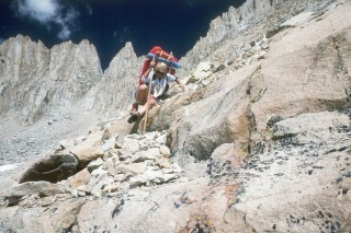 The descent from Crabtree Pass was not too bad, but the boulders over which we had to move were larger, and often required scrambling. It was not physically difficult, but it took a lot of time. Our original plan had been to get over the Pass, down through Crabtree Lakes, and then north to the turnoff to Mt. Whitney. It retrospect, the plan seemed ludicrously ambitious - the XC part of the route just took too much time. I felt more tired than I would have expected so soon after lunch, and having traveled only a couple of miles. We worked our way down to the first lake in the drainage, and were not surprised to see that yes, the snow field was much steeper than it had looked from the Pass. (An analysis of photos taken during the crossing indicated that the angle was "only" 28 degrees. That doesn't sound very steep until you get on it.) And the consequences of slipping and sliding were not fun to contemplate. From my vantage point at the NE end of the field, it looked like if you could not stop yourself during a slide, you would take a dive right into the lake. We started to very gingerly cross the field, with George doing the honors (he seemed to have the biggest boots, so he could kick the biggest steps) followed by me and then Sunny. Of course, we crossed without incident, thankful we were doing the crossing on a warm afternoon, when it was easy to kick solid steps. But I think we all breathed a bit easier. From that point, it was rocky, but not threatening as we moved down the drainage. It was starting to cloud up, and so we tried to pick up our pace just a bit, which is tough when you are negotiating boulders. By the time we were down from the snowfield perhaps a mile, the going became a lot smoother. Still some boulders, but lots of grass and sand, and we started looking for a place to camp. We settled for a small shelf maybe 100 feet above the level of the largest Crabtree Lakes.
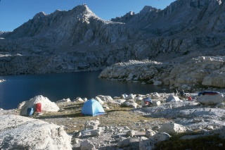
 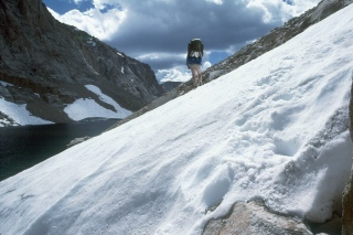 We had great water, and those classic Sierras granite benches on which to spread out our gear. While the lake level was only a hundred feet higher or so than that of Chicken Spring Lake, it felt quite different. No trees around at all, just grass and scattered wildflowers. We could not see any evidence that the clouds were rain producers, so we went about the business of getting cleaned up. We had only covered 4 miles from Sky Blue Lake, but it had been slow going, and I felt like I had run out of gas, so it was a fine place to call it a day.
We sat on the rocks, reviewing the fun we had that day, congratulating ourselves for having had this wonderful wilderness experience, and having yet to have taken a single day off from work. We were treated to a spectacular display as the sun dropped below the now-dissipating clouds. Tomorrow, we would drop out of the drainage, and pick up a real trail, and head back up to the high lakes to the west of Mt. Whitney, and position ourselves at Guitar Lake for getting to the summit the next day.
© Roger A. Jenkins, 1986, 2001