Side Canyons of the Lower Escalante 2005
Decisions, decisions
Tuesday, April 26 During the night, some other folks moved in downstream of us, and made a considerable amount of noise. Most of us ignored such, however and slept through it. We awoke to another lovely, albeit slightly warmer morning. Since our goal was not far, we had a pretty leisurely time breaking camp. We were headed for the confluence of Coyote and its so-called Dry Fork. There are some really neat slot canyons way up the Dry Fork (out of reach of a base camp at the confluence), and I was hoping that some of the side slots lower down would be at least semi-interesting. So the plan was to consider a base camp at the confluence. If it did not look promising, then we would move on the next day.
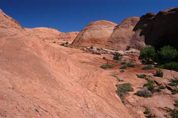 It is easy to get side tracked in canyon country. We did not leave camp until 9:40 am, and stopped within a half hour at a side canyon that looked interesting. Sometimes, one gets lucky. Susie, Barbara, and I, with Will not too far behind us, thrashed through the brush of a drainage whose mouth is across from 12S, 494509E, 4141712N. We climbed up on some slickrock benches on the left side of the drainage and was rewarded with blooming cactus, interesting slickrock bedding, Moqui Marbles, a couple of pools, and some peeks of Fifty Mile Mountain. Boy, was it neat. The four of us must have spent an hour in there.
We ran into the rest of the crew just above the mouth of Sleepy Hollow, well worth some serious exploration in its own right. They reported meeting up with Ray, who was day hiking out of his camp upstream. So that was a good thing, and everyone was together again. Susie and I and Barbara kept hiking until about 12:40, when we stopped for lunch. The canyon walls were getting a bit lower here and we are looking for good shade to rest and refuel under. During lunch, Ray showed up, reporting that there was a good bench for camping, just upstream of the Dry Fork confluence in the Dry Fork. So that was encouraging. Then we started asking him where his tent was, since we had not seen it. Now Ray refuses to carry a GPS with him, even though he is/was a professional engineer and a technical kind of guy. He prefers the old way of relying strictly on map reading ability. Well, we started showing him where we were on the map, and he kept saying we could not be there, because he had camped at such and such a place, and described it to us. I tried to explain to him that we had a pretty good fix on our position, and there was a great deal of congruity between where the GPS was telling us we were, and the surrounding terrain, based on what the map was showing. So then Ray started to show concern. If we were where we said we were, then his camp, with all his gear, etc, must be downstream. Which means he must have missed it as he moved upstream. He was really disgusted with himself. We tried to argue with him that since a whole bunch of us had been moving upstream, it is unlikely that all of us would have missed his camp and thus, his camp must be upstream of where we were now. However, we could not convince him, and so he headed off downstream, shaking his head.
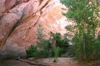 Naturally, just a few minutes after we left our lunch spot, we came across Ray's tent, and Ron graciously volunteered to drop his pack and try to catch Ray before he walked all the way down to the mouth of Hurricane. Meanwhile, Andy, Sue, Barbara, Susie and I moseyed along up canyon, admiring the big walls that had moved in our left, and the distant views when we had to climb up steeply around a narrow pouroff. I knew we were coming up on the confluence, so I relaxed and chatted for a bit with a couple from Missoula, MT, while I mentally left Susie, Sue and Andy to find the supposedly delightful camping benches that Ray had mentioned. Big mistake, since I had not told them such was what I was doing. Pretty soon, Susie, obviously upset, came back to me, wondering what had happened, and explained to me that there were no obvious camping spots at the confluence, or right above it. In fact, the area had lots of mosquitos, given its proximity to what amounted to a swamp between the two arms of Coyote. Hmm ...... This did not sound like the place Ray had described. So when I arrived at the confluence, it was like: OK, Mr. Leader, what in the hell do we do now??!! The first thing that we tried was looking upstream in the Dry Fork for the benches Ray described. Instead, we found mounds of sand, and thick vegetation in the streambed, but very little water flowing. And so we headed upstream in the main fork of Coyote, for a couple hundred meters, and found nothing suitable in sight of the steam bed as well. All low brush. And, of course, the mosquitos from the swamp. And Susie and mosquitos just do not get along well. None of us are big fans of them, really.
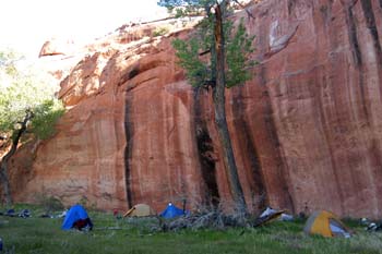
By this time, Ray had shown up, and wondered why we were not camping up on the bench that he had found. I told him we could not find it, but he wanted to show it off, and I felt like it was my obligation to at least take a look at the place. Well ..... It was not exactly along the stream bed of the Dry fork. You started there, and then, after busting through some dense vegetation that lined the back of the pond/swamp, climbed an amazingly steep sand slide, up to a shadeless, semi-flat area with scattered grass. Given the difficulties I envisioned in getting backpacks up the slope, this did not seem to me to be heaven on earth when it came to canyon camping. Fortunately, Ron saved the day, by banging through the stream side brush in the main fork, and found a delightfully grassy and shady camping area (12S, 489572 E, 4142516 N ) perhaps 40 feet above the canyon floor. OK, it was not too convenient for restroom facilities (a steep sand descent, walk out and cross the stream bed, and go back in the bushes, near the "swamp") or water (the aforementioned descent and then a 200 meter hike back to the confluence), but it was otherwise perfect, and I was thankful that most of the glaring at me had stopped. 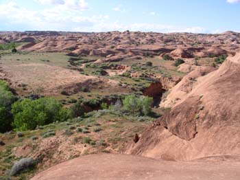 (The problem with mentioning aerial photography too much is that people come to expect that you know all there is to know about a particular area.)
Actually, it turned out to be a great campsite. Ron and Will went off exploring after they got here, and reported that the Dry Fork, above the confluence, was buggy, with big sand benches on either side, and not very attractive. It was clear that Will was ready to move on to the rest of Plan B, and that seemed pretty fine to me and most everyone else. So while we were wrapping up our dinner of Orzo and chicken and spices, and the sun was setting, and Barbara was off photographing, we all decided we would pull up stakes in the morning, head out for our vehicles at Red Well, and get on to Davis Gulch. See something new to all of us.
© Roger A. Jenkins, 2005; Dry Fork Coyote photo © William H. Skelton, 2005