Side Canyons of the Lower Escalante 2005
Imcomparable Narrows
Saturday, April 30
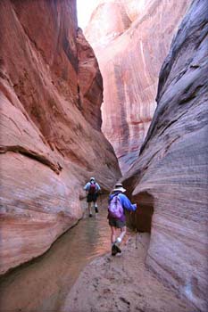 Our last full day on the canyon trip, and what a day it would turn out to be. The rangers had mentioned that there were some narrows just below the high water mark in 50 Mile. And a fellow that we had met in the canyon (our first other human since Tuesday afternoon) had mentioned he "did not want to spoil the surprise" for us downstream. We had decided to treat today as a semi-layover day. That is, we would pack up most of our gear and spend the morning and early afternoon hiking downstream to see what we could see. Most of us were out of camp by 9:15 or so. We walked downstream, just below our final descent point and turned into a really neat section of narrows. After a hundred meters or so (the water was running down canyon strongly enough such that there was no way we were going to get through with dry feet) we got to the end of this stretch, and said: "Boy, those were really neat narrows. Now, let's head for the lake." The canyon opens slightly and then we came to a small pour-off that we worked our way around on canyon left (going downstream). I was still up on top of the falls, taking pictures, when Barbara, who had gone around first, yelled back to me: "Oh my, Roger, you have GOT to see this!" Well, it was more narrows. Lots and lots of them. In most places, the walls were ten feet or so apart, but in a few spots, the walls would narrow to five or six feet. The water depth varied from ankle to mid-thigh, but there were no stagnant, or semi-stagnant pools as had been the case in Buckskin Gulch. And these narrows seem to go on and on. (I should have marked the end of the narrows, but I do know that it took Susie and I, when we did turn around, about an hour of pretty quick hiking to get through the narrows.) There was one spot where we finally broke out into the sunshine, and all the ladies posed for a group photo leaning up against the canyon wall in the sun. Then we plunged back into another stretch of narrows. It was absolutely the geologic highlight of the trip. However, one of the things that concerns me, as I write this, that with the water now back up 50 feet since we hiked in 50 Mile, how many of these narrows are now in their drowned configuration?? Many of us are hopeful that such will only be a temporary condition.
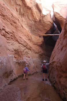 The narrows finally peter out, and the canyon floor quickly turns from nice hard sand to thick, gooey clay. Yuck!! Most of the group kept going, but after a few hundred yards of the goo, Susie and I decided our time could be better spent eating lunch back in camp. So we turned around, what turns out to have been just a couple of bends short of the Lake's water line. As mentioned, it took about an hour, hiking full tilt, to get back through the narrows and above the high water mark to camp. Ray was already there (having turned around earlier than us) and we chatted with him for a bit in the shade. He told us, sadly, that while he had really enjoyed the last 25 years of canyon trips (he made all but two or three of them), he knew his body was telling him that this was to be his last week-long backpack. We had noted that he had a vastly more difficult time getting down the slick rock slope into this canyon, clearly having a problem with balance. It had been hard for us to see that, since it had always been Ray's balance and strength upon which we had relied to help us over the really tricky spots on our trips (see our 1997 Wind Rivers trip, for example). And of course, hearing this from Ray, we both knew it would be just a matter of time and we would be saying the same words. But, as Ray would say: "That's the way it is."
The rest of the crew started showing up and Susie and I mostly sat in the sun, drank a lot of water, and generally relaxed until about 1:40 pm, when the read-out from my watch shamed us into finally taking off. We knew we would not have to travel a great distance up canyon, since the flowing water was supposed to run out just above the confluence of the West Fork of 50 Mile and the main fork. A little less than a mile of walking brought us to the Kelsey entrance, a large sandslide that comes down from the canyon rim. It looked from the stream bed as though it would be easy to get down on to the slide itself, and either the right or left side could be followed, albeit with a bit of scrambling, all the way to the canyon floor. (For those interested, the top of the sand slide is about here: 12S, 502207 E, 4129125 N.) The sand slide definitely looked easier than what we had done. However, we all agreed that our way was neater, because it was more of a challenge, and dropped you down a) right across from the entrance to the narrows and b) just about 150 m downstream from a fairly nice (Susie said it was the best of our trip) campsite. That said, the sand slide had a campsite not too far upstream from it.
 We stopped for rest break maybe a half mile above the sand slide bottom. A couple of guys were backpacking downstream, and wanted some details as to where the lake water started. Seems that they had each brought small rafts with them, and they were going to float and paddle their way to the main channel of the Lake (the drowned Escalante River canyon) and then down to the mouth of Davis, and paddle up Davis until they ran out of water. And then hike out. We explained to them where the Lake started, and where possible campsites were. It was not clear to me that there were any places to camp between our spot last night, and perhaps a few hundred meters below where we had camped the night before. That looked like maybe 4 or 5 miles of lake paddling and a couple of miles of backpacking on each end. Sounded like a pretty full day when they did decide to go for it. We hope they made it comfortably.
We had stopped near a huge overhang, but decided to push on, a) because it was a tad buggy and b) because we wanted to get as far up 50 Mile as possible to make tomorrow shorter. Susie raised the inevitable question: would it make more sense to go out this afternoon, since it was still relatively early. My gut feel was that such was not a particularly good move, since we still had perhaps two to three more hours of hiking, just to get to the Highlander. Then we would have to run a car shuttle to pick up the van, so we were looking at maybe 6 pm before we were saddled up and ready to move. Then, we were looking at probably 3 hours up HITR Road to Escalante. So it would be a very long time until dinner, and there was the unknown of whether any rooms would be available in town. No, it seemed that the canyon offered a better deal. So we pushed on, the two guys having said that the water ran out about a half mile above where they had stopped to talk with us. By this time, Ron had joined us, and we moved up canyon, but the water very quickly ran out and there were few places to camp that were pleasant. So the place that we had stopped seemed to be "it," and thus, we turned around.
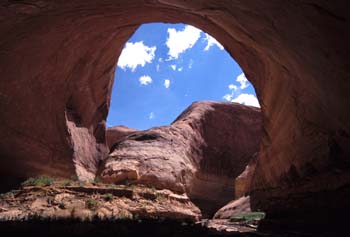
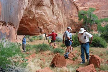 Our campsite ( 12S, 501507 E, 4129117 N ) turned out to be pretty neat. There were acres of relatively flat spots, and a huge overhang under which we could cook if it rained, and there is an arch against the canyon wall (you cannot see it as an arch unless you look from just the right spot). But the real piece de resistance was a panel of petroglyphs, the likes that I have not seen, in terms of sheer number of images, since I saw Newspaper Rock many years ago. The panels were just covered with interesting images. And one of crew reported that there were more upstream. This did look like a special place. We cooked dinner underneath this mega-overhang, and I was in a real comfy spot in my chair, until Susie pointed out that I was sitting right near a spot where rocks had fractured off the ceiling of the overhang and hit the sand, and anything sitting on it, with a big splat. I moved my chair just a tad. Sure enough, the no-see-ums had found Susie, and she decided to put her bug net on. It is amazing how bugs seem to find her first. Maybe it is her shampoo, or, more likely, the heat or carbon dioxide she gives off. Anyway, she was a lot more comfortable once she had her bug net on, despite all the chiding. It being our last night in the canyons, Ron made a delightful lemon muffin cake for a shared dessert. That was kinda neat. We chatted in the enveloping darkness until 9 pm, or so, and then Susie and I plodded off to bed. The plan was that we would be up by 6 am. Sue and Andy would boil water for our breakfast, so we could pack our stove, etc. Ray would leave camp at first light, and Susie and I would be on the trail by 7:30 am, such that I could run the car shuttle with Ray. It had been a superb trip, in ways much better than expected, but now, it was time to think of heading out.
© Roger A. Jenkins, 2005