
Side Canyons of the Lower Escalante 2005
Layover in Davis
Thursday, April 28
 Finally, a layover day. I was soooo ready for it. And today's hike would have a lot going for it. First, for the last 70 years or so, Davis Gulch has held an aura of mystery about it. Something happened there, for sure, but only a few people still alive know the answer, and they are not telling. In 1934, a twenty-year old poet and artist, Everett Ruess, (http://www.everettruess.net/ )disappeared in Davis Gulch. His burros and campsite were found, but, despite a massive search effort, not a trace of him. There are several theories. The one that seems to make the most sense is that he was murdered and buried by cattle thieves or people from the town of Escalante who considered him too weird. But his disappearance is a mystery, and most anyone who has spent time hiking in canyon country has at least heard of Ruess. Many of the canyon backpack regulars on this trip had read his albeit short biography and collection of writings. So just seeing the place where Ruess disappeared was of interest. The fact that we could actually SEE this canyon, without the benefit of scuba gear, was another major attraction. So we set off for an interesting day.
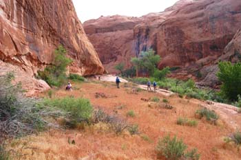
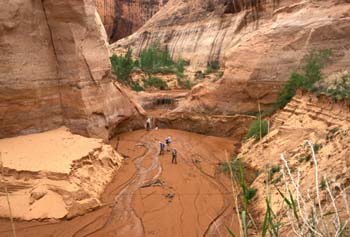 We did not get very far. The first distraction was a huge garden of wildflowers and cacti, all blooming in profusion, just downstream a couple hundred meters from camp. In addition, we found a wall of petroglyphs near the flowers. Already, this was turning out to be a special place. There were some spectacular purple flowers that Susie and I decided we would photograph on our way back up canyon. Bad idea. We subsequently learned that these are Four o'clocks, that typically bloom in the early morning, close up, and then open their blooms again, around, you guessed it, 4 pm. OK, maybe next time. As we worked our way down canyon, it was clear that the bench we were on was above the high water mark of Lake Powell, just barely. We did come to a place where it was relatively easy to drop down to the floor of the canyon. Which was good, because we were quickly running out of bench and would cliff out. When we got down to the floor, it was not like something we had hiked upon before. Perfectly flat sand on the bottom. No banks for the most part, just sand that spread to the walls (and the stream, of course). It quickly dawned on us that we were seeing evidence of the inevitable silting up of Lake Powell. What happens is that the sand gets washed down from the mesa tops during storms. Under natural conditions, the sand would build up benches slowly, because the flowing water would carry the silt to the river. Well, when you convert the canyon into a Lake, which is what the
 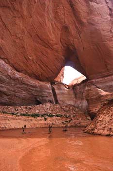 Bureau of Reclamation did in the ‘60's, as soon as the flowing silt laden water hits the pool of water, it slows and drops its load of sand and silt. And so the lake fills up from the bottom. We had the sense that we were walking ten or fifteen feet above the original, pre-Lake streambed. Very strange. Another interesting phenomenon: mud potatoes. These were potato shaped globs of mud. If you looked at them on the sand floor, you would swear that they were potatoes. You could even stab them with your walking stick, pick them up, and carefully fling them against the canyon walls. This was something we had never seen before in canyon country. Maybe it was just a case of never having been in a place with the right kind of mud.
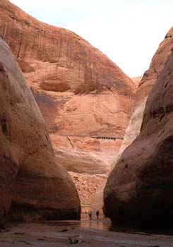
We did have to climb up and then descend around a small pour off/waterfall (there was plenty of water in the stream bed.) We came across a crayfish in the middle of the canyon floor, but avoided disturbing him or her too much. We went through a small section of not-too-narrow narrows, and then went past LaGorce Arch. It was pretty incredible to look up, way up, and think about the fact that in past years (the Lake was full as recently as 1999), there were waves lapping at the base of the Arch. A few more turns, and we arrived at the current high water mark. Frankly, it was kinda ugly, as there were dead, rotting trees standing in the middle of the canyon, drowned decades ago, and just recently revealed to the open air. I walked over and looked at the water, and could swear I could see if flowing in. Everyone else discounted such, but if you check the Lake Powell database for this date (http://www.summittech.com/LakePowell/LP_WaterDB.php), you can see that at the time, the Lake was in fact, coming up. On this day, the water level was way down (3562 feet) from full pool (which is 3700 feet) but the water had risen three feet in the last week to fill the canyon to this point: 12S, 506217 E, 4129459 N. Since there was no more new territory to cover without swimming, we thought this would be an excellent time for lunch. During our repast, we noted that a couple of boats came up to the minimum possible water depth and then quickly turned around. (They probably thought it was ugly down here as well.)
On our way back, Sue pointed out to me something really interesting: there was a Pepsi can buried in sediment, high up on a grassy bench past which we were hiking. That means that the can had been deposited several years (perhaps decades) ago, the silt, maybe two feet deep, had settled in on top of it, grass had started to grow sometime recently, and that erosion was cutting away at the sediment fast enough to reveal the can. The fact that the can was probably 20 or 30 feet above our heads was indicative of just how fast geologic processes are working to fill Lake Powell. It is interesting that when you stop and think about what you see in the mountains, this should not be surprising. Beaver move in, dam a little creek. A pond is formed, it fills in, and pretty soon, you have a nice meadow. I am just not sure that humans are as smart as the beavers, when it comes to choosing their places to store water.
Susie and I got back to camp fairly quickly, as walking on the hard sand went pretty fast. We decided to hike just a bit above camp (an activity that required some brush thrashing), and see what we could see. We found some pictographs just above camp on canyon right, and they were marked with a NPS sign telling us not to deface them. It has come to that!! We moved further upstream and got out into the open a bit, and looked around, surveying the work that the beaver had been doing in re-engineering the creek bed.  Lots of hard work out there. But then, both of us were slammed with an attack of the lazies. It was time to turn around, relax, clean up and think about cocktails and dinner. Well, at least dinner. We did have dinner a bit earlier tonight, with the threat of potential rain. Everyone was back in camp early, and it seemed to be the thing to do. That way, if the skies did open up, cooking chores would be over and we could just dive into our tents. As it turned out, it spitted a bit during dinner, and I modeled my new Precip Rain pants, (had to pull them out of the packaging to put them on), but it was only a threat, and we were still able to have a two hour discussion on things that seemed important then. Sue remarked that she thought a cold front was moving through, and most of us agreed that such would be fine, as long as the rain was confined between the hours of 10 pm and 5 am.
© Roger A. Jenkins, 2005; Pour-off/sand floor photo © Suzanne A. McDonald; Potato Man photo © Andrew P. Butler, 2005