Side Canyons of the Lower Escalante 2005
Into Davis Gulch
Wednesday, April 27
 I awoke to a smattering of rain drops and a sour Susie. I think she could have been talked into bagging things all together. I could sense, and she later verified this, that in addition to the weather, that was admittedly looking very inauspicious at the time, she was concerned about our Plan B, that required hitting a stock trail on the north rim of Davis Canyon, after miles of overland travel. There were just too many uncertainties for her comfort level (Uncertainties seem to bother her much more in canyon country, with the prospect of muddy roads, than they do in the mountains. Go figure.), and of course, the mosquitos trying to get into the tent did not help. But we packed up, the rain temporarily stopping, and headed up canyon, moving as quickly as we could, and hoping the rain would hold off until we could at least drive the cars to where they needed to be placed. In a sense, this was an entirely new backpack. We would pick up more food and fuel at the vehicles, and head off for Davis Gulch. After two nights, we would climb out of Davis, and attempt to find a route that the Park Service had marked as "Steep" on its topo map into 50 Mile Creek Canyon. After two more nights, we would walk out of the head of the West Fork of 50 Mile Canyon.
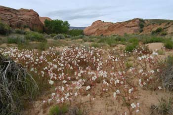
But first, we had to get to Red Well. Not very far, perhaps 1.5 miles from where we had camped. Susie and I were rolling by 8:55, and it did not take us more than an hour or so to get to the bottom of the steep hill that one climbs to exit at Red Well. There were a few flowers along the way, and I stopped to photograph them, albeit with marginal lighting. Since the creek bed dried up just a few hundred meters above our camp, the stream bed was just another sandy wash, with many twists and turns. Apparently Robin got "confused" in one of them, because when we got to the top of the climb out, Robin was nowhere to be seen. But about 15 minutes later, she showed up as a distant speck moving up canyon and admitted her "confusion" when she climbed out, having taken a wrong turn into a side drainage of the canyon.
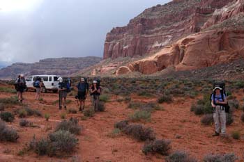 It must have taken us nearly an hour to get the mile and a half out to the HITR road and the 14 miles or so to the point where we would drop off our Highlander. The road was increasingly rocky, and cut with stream beds, from the drainages running off 50 Mile Mountain. We got to the spot recommended for parking at the West Fork of 50 Mile and it was a regular traffic jam, thanks due to a number of horse trailers parked in the tiny parking area, and the fact that the parking area was cut by a stream bed. We ended up squeezing the Toyota into a spot, barely. We loaded up in the van again, and headed about 4.5 miles further south, and pulled out at a nice slickrock covered area, recommended by the Park Service for those taking the overland route into the downstream end of Davis Gulch. Bad idea. As we munched on lunch and turned our heads to discern the direction of the next incoming thundershower, I began studying my map, a conventional topo of Davis Gulch that I just happened to have with me, and had marked up at the Visitor Center. I realized that while the Park Service recommended parking where we were, the recommended location of the overland route into Lower Davis took off from a high point a half mile back. So we all piled back into the van, and drove back up the hill, trying to conserve as much energy and water as possible. Now, what we had for guidance here were Park Service Handouts, not too much help at this point, our hastily translated marks off the Park Service topos, and a couple of pages Barbara had graciously permitted us to tear out of Kelsey's third Edition of his Canyon Country Hiking Guide (as long was we promised to replace it with the Fourth Edition - she ain't too dumb!). Not a lot to go on. Given our luck at getting into Bowdie Canyon last year, no wonder Susie was more than just a tad skeptical.
 The route we took in was designed from the NPS guidance to stay out of the side drainages of Davis Gulch, and Kelsey's guidance to first head for a nipple-like feature maybe a mile or a mile and a half north of HITR Road. (Actually, in his third edition, he says head left of the nipple, and in his Fourth, head right. In the field, I don't think it makes any difference.) Fortunately, we did have the key point of information: the location of a supposed stock trail into the west side of Davis gleaned from the NPS-marked topo map. Of course, trying to translate locations when one is in a rush to hike is can be a challenge. I was hoping I had gotten it right, as I translated the position on the map to a GPS coordinate.
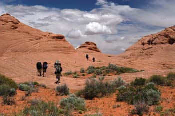
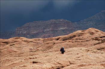
We left the van a bit before 1 pm, exasperated at the amount of time it had taken us to "change horses." We got out to the edge of a hundred foot plateau just northwest of the van (12S, 501778 E, 4123028 N) and decided it would be easier to continue skirting the edge rather that descend. We moved as quickly as possible, because while it was blue sky and puffy white clouds directly over our heads, there were storms all around us. It would only be a matter of time before one of them slammed us. We moved along at a pretty good pace. It seems many of us were tired, but for whatever reason, my adrenaline was pumping overtime. We stopped for a brief rest after 80 minutes or so, and I was pleased with our progress. But the storms were coming and the wind was picking up. I now turned my GPS on full time and watched the meters roll by. I announced we were less than 2/3 of a mile from the stock trail, as we stopped to put on our rain gear.
OK, it is time for the humor break. Remember that Ray drove all the way into the town of Escalante the first night to buy some rain gear?? Well, he found some all right. What kind of rain gear do you think you can get for $5 in the town of Escalante?? "Not much" would be a good guess. It was amazing: like a giant plastic Zip Lock bag, and just about as thick. The first time he put it on, the crotch split out. (Maybe Ray is just one helluva man!!). But he had his sorry-ass $5 rain suit on as he trudged across the slick rock. It provided some levity to what was becoming a less-than-completely-pleasant situation.
When we got under a third of a mile to the waypoint I had set for the start of the stock trail, the rain hit and with it, the wind. The rock got slick and I had to really pay attention. I could "feel" I was getting closer, as I could see a depression ahead, which might mean a place to get down, even though we were still 300 feet above the canyon floor. The wind just howled, and the rain felt like little bullets. As I neared the lip, I could see a small rock cairn ahead, and so I dropped my pack, and waved my arms, trying to signal what I thought was the right spot. At least the first 100 feet or so looked doable. Some of the folks were waving their arms at me. I thought they meant: "Ok, we see you." But it turns out that they were pointing to another set of cairns. I did not learn that until later. As the group caught up, the storm slowed, and the wind died. It reminded me of the thunderstorm part of Grofe's Grand Canyon Suite. Majestic to listen to, but not a lot of fun to be outside in.
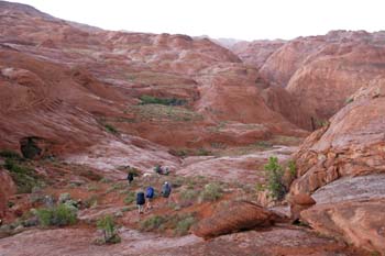
 Here was the challenge: at the point where the trail was supposed to descend, (click here for map of overland route) there were lots of mounds of slickrock. It meant that one could not see very much territory at one time. As a result, you could not be sure that there was not a better route just around the corner. But the first part of what loomed in front of us looked pretty do-able so we decided this would be the route we would take. After descending a short distance into a garden of wildflowers, some of the crew started searching for the next part of the route: that which would get us those last crucial 200 feet or so to the floor of the Gulch. However, not much luck was being had. Will was reporting that he had found what the NPS had called a "friction route." That was new information to me. I thought there was only one route, but Will reported he had heard of two routes, and that this other one looked possible, but pretty scary, to get down a convex sheet of sloping slickrock. I decided that I must not have found the real stock trail, but rather, the cairns for the "friction route." So I headed back along the rim (upstream) maybe a hundred yards or so, until I could see a bit more (it had been so frustrating NOT being able to look around and get the big picture). As I crested a small rise on the rim, I looked over into a bowl, and could see a thin cut in a huge slab of light concave slickrock. It looked like someone had blasted out a flat area for the stock (translate: dumb cows) to walk. I descended to that line, and realized I had indeed found the trail. I switchbacked hurriedly down to the just above the canyon floor, to confirm that this was the route, and then hurried back to report that I had found the "approved" route. Susie was sitting over near a corner of the flower garden, obviously conserving energy, as she often feels that the uncoordinated scouting could be a little more ...... well ..... coordinated. I was thrilled, because we had found the way into a canyon that promised to be both historic (Davis Gulch is where Everett Ruess disappeared) and interesting. I could see that there was moderately good camping and water right at the floor of the trail, and frankly, I had had sufficient "fun" for one day.
 I think Susie and I hit the floor of the canyon by 5:20 pm. Not exactly a speedy way to go 3.5 or 4 miles, but that is the way off-trail hiking and route finding is some time. I was ready to get cleaned up and have dinner, if only the rain would hold off for a bit. The wind had picked up again (although not to its previous gale force) and I knew such would make open air bathing a bit refreshing to downright chilly. The place (12S, 504389 E, 4127931N)actually turned out to be pretty good to camp, but I was glad we had a pump with us, since there was lots of evidence of beaver and the water was fairly cloudy. We sat around talking that night of the day's travels, and why we had missed the real stock trail. We also got into an interesting discussion with Robin about her experiences in Outward Bound. (Canned food on a week-long backpack???? Packs that did not fit? This is supposed to teach you leadership???) Sounds to me like my respect for the leaders and organizers would have been so low that anything which I might have learned would have been lost.) As Susie and I were heading off to bed, the rest of the crew started some evening calisthenics, a tradition I could do without. I had experienced plenty of exercise that day.
© Roger A. Jenkins, 2005; Dark sky photo © Andrew P. Butler, 2005