Side Canyons of the Lower Escalante 2005
We're Outta Here!
Sunday, May 1
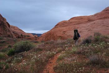 We were up way before 6 am. I could hear Ray packing up his gear, albeit vastly quieter than our first canyon trip together in 1980, where he would get up early, and shake the plastic sheet he was using as a tarp for all it was worth. Susie and I had things pretty well organized, and Sue and Andy had a nice amount of boiled water for our coffee and granola. It did spit rain a tad, and it was nice to have the overhang under which to do our final packing. Sandy, but nice and dry. Ray was outta there way before us, thinking he would be moving slowly. Barbara also left a tad ahead of us, but Susie and I were rolling by 7:15 am. It seemed like we were hiking at twilight, because of the black, presumably getting-ready-to-rain-on-us clouds all around. We had opted to exit via the so-called West Fork of 50 Mile, probably because the route out is much shorter, and since there was no water in either fork, the shorter route seemed better.
As advertized, the floor of the West Fork can be rocky at times, but otherwise, it is pretty smooth sailing. The canyon itself is pretty nice, and would make an interesting day hike in cool weather. And it was cool this morning, for sure. Susie was hiking in her long sleeve flannel shirt. The canyon opens up for a bit, and then the walls narrow down, so 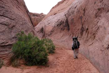 pretty soon, within a half mile or less above the confluence, you are hiking in pretty tight narrows, perhaps 12 - 15 feet wide. Very nice. We knew from reading Kelsey, that there would be a pour-off blocking our direct exit from the canyon. So we kept an eye out for any sign of paths leading out on either side. (Will actually went up to the choke stone that blocks the route forward, and it was a good size hunk of rock.) It was not hard to find a path marked with cairns on canyon right headed out. There was one piece of steep slick rock, but it was not hard to negotiate. We turned around and looked, since Kelsey indicates that you can out on either side, but we could not see any evidence of an exit route on canyon left (heading upstream), and the route we were on was fairly obvious (no real need for cairns). We left the narrow section behind and started moving quickly on huge slabs of clean rock, just like walking on a sidewalk. I had not taken my GPS out yet, because I figured the way to the shuttle vehicle would be pretty obvious.
We got to a place where the sense of canyon completely changes to that of a broad wash, and water was running in the stream bed. I turned on the GPS, indicated we ought to bear left, and before we could see the Highlander, we heard a truck coming down the road, so we knew our hike had come to an end. Ray was waiting patiently for us and it was time to run the shuttle.
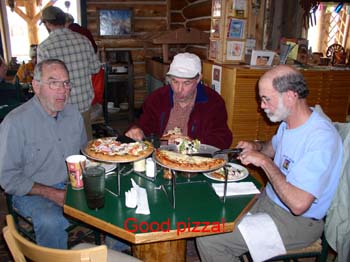 The van was probably only 4.5 miles south of us on HITR Road, but the road is rough, and we were probably gone well over a half hour. By this time, the rest of the crew had come up the canyon, so we were ready to pack and high tail it for pizza in Escalante. OK, maybe low tail is more like it: I recall it taking something like 2 + hours to get the 45 miles or so back up the road. The mud was thankfully gone, and in its place were rough-as-a-cob washboard. We had gotten a bit of a taste of such on the way it, but it seemed worse now. We could see dark rain clouds gathering and we were happy to be leaving them for the time being. Pizza at Escalante Outfitters (surprisingly high quality for such a small place, although if you order a glass of wine, be prepared to spend major $$) was followed by purchasing a replacement Canyon Hiking Guide Fourth Edition for Barbara, and getting T-shirts and gifts and the usual stuff you get when you re-enter civilization. Even Susie sprung for a T-shirt. It MUST have been a great trip.
© Roger A. Jenkins, 2005; Eating pizza photo © Barbara Allen, 2005